At a glance
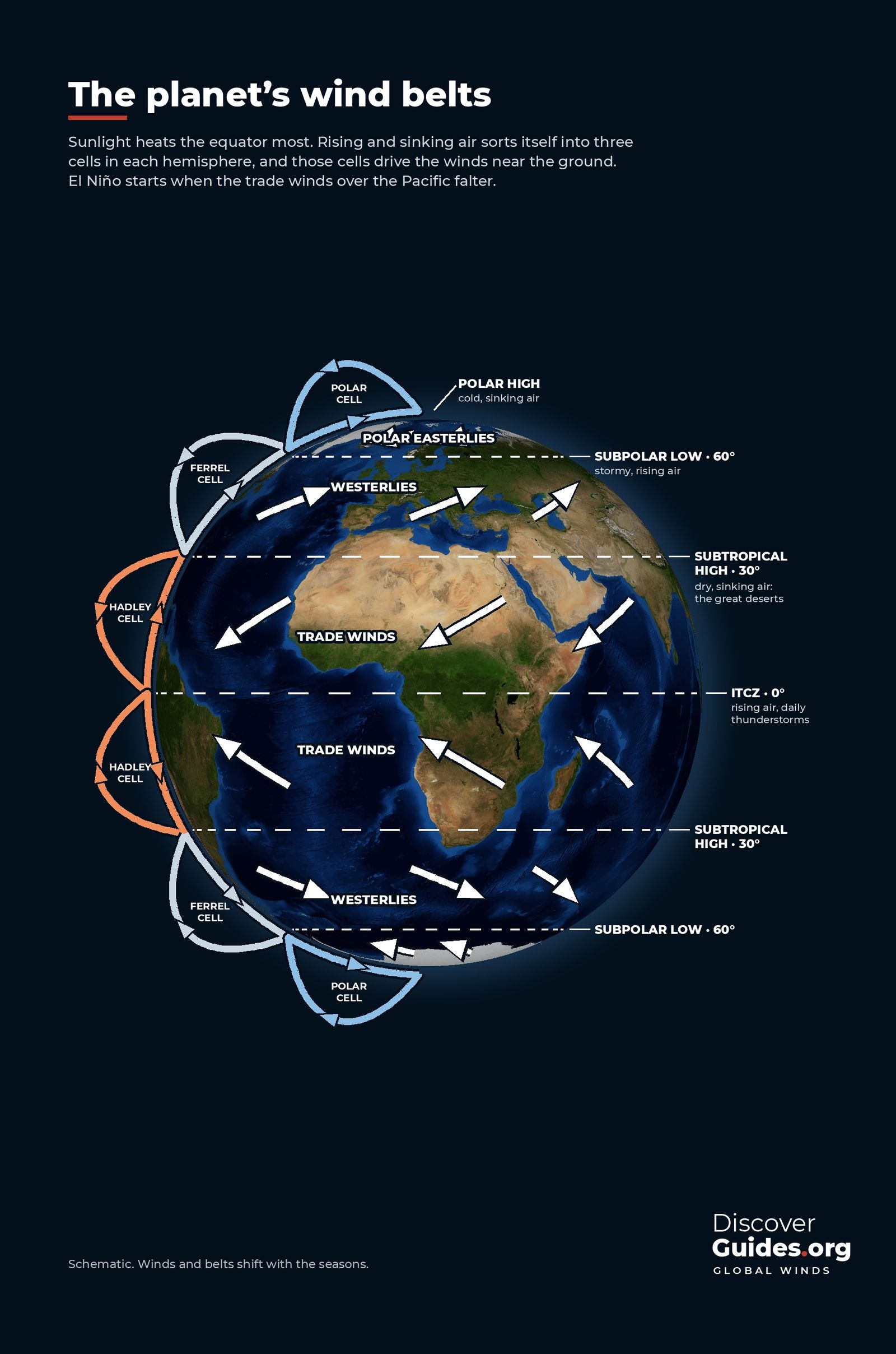
The sun heats the equator far more than the poles. The atmosphere and oceans spend their lives moving that surplus heat poleward. If Earth did not spin, the job might be done by one giant loop in each hemisphere. Because it does spin, the circulation breaks into three loops, or cells, and those cells set the winds near the ground.
The Hadley cell: the engine of the tropics
At the equator, warm moist air rises, cools and drops its water as heavy rain. High up, that air flows towards the poles. By about 30° north and south it has cooled and piled up, so it sinks. Sinking air warms and dries out, which is why the subtropical highs near 30° hold most of the world's great deserts, from the Sahara to the Australian interior.
Near the surface, air flows back from the subtropical highs towards the equator to close the loop. Earth's rotation deflects it (the Coriolis effect), so instead of blowing straight south or north it blows from the north-east in the Northern Hemisphere and from the south-east in the Southern Hemisphere. These are the trade winds, named for the sailing routes they powered.
The ITCZ: where the trades meet
The trade winds of the two hemispheres converge in a band near the equator called the Intertropical Convergence Zone (ITCZ). Here air rises, clouds tower and thunderstorms form almost daily. Sailors knew the calm, sticky zone as the doldrums.
The ITCZ is not fixed. It follows the sun, moving north in the northern summer and south in the southern summer, and on average it sits a little north of the equator. Its seasonal march brings the wet seasons to much of the tropics, from West Africa to the Amazon, and it feeds the monsoons of Asia and Australia.
The Ferrel and polar cells
Between about 30° and 60° lies the Ferrel cell. Near the surface, air flows poleward from the subtropical highs and is turned east by Earth's spin, giving the prevailing westerlies that carry weather across North America, Europe and the Southern Ocean.
At about 60°, the westerlies meet cold air flowing out from the poles. The boundary, the subpolar low, is a stormy zone of rising air. Beyond it, the polar cell brings cold, sinking air over the poles and sends it outward as the polar easterlies.
| Belt | Latitude | Surface wind | Typical weather |
|---|---|---|---|
| ITCZ | Near 0°, shifts with season | Light, converging | Rising air, daily thunderstorms |
| Trade wind belt | 0-30° | Trade winds from the east | Steady winds, showers |
| Subtropical high | ~30° | Light, sinking air | Dry: the desert belt |
| Westerlies | 30-60° | From the west | Changeable, storm tracks |
| Subpolar low | ~60° | Converging | Stormy, rising air |
| Polar high | Poles | Polar easterlies | Cold, dry, sinking air |
Where the jet streams come from
The jet streams are the high-altitude edges of this system. The subtropical jet forms near the poleward edge of the Hadley cell, where air that rose at the equator flows out at height and is turned east by the planet's spin. The polar jet forms above the sharp temperature contrast between polar and mid-latitude air. Both blow from west to east and steer the storms that cross the mid-latitudes. How El Niño moves them is explained in How El Niño Bends the Jet Stream.
Winds drive the oceans too
The wind belts do not only move air. Blowing steadily over the sea, they drag the surface water with them and set the great ocean currents in motion. The trade winds push the equatorial currents west across the Pacific and Atlantic, the westerlies push water east at higher latitudes, and together they spin the huge circular gyres of each ocean basin. Along coasts such as Peru and California, winds blowing parallel to the shore pull surface water offshore and draw cold, nutrient-rich water up from below, feeding some of the world's richest fisheries.
The Pacific's extra loop: the Walker circulation
The cells above run north-south. Over the equatorial Pacific there is also an east-west loop. Trade winds push warm water west, where it piles up near Indonesia. Air rises over that warm pool in great thunderstorms, flows east at height, and sinks over the cool eastern Pacific, then returns west along the surface as the trades. This is the Walker circulation, named after Sir Gilbert Walker, who discovered the pressure see-saw behind it (see The Southern Oscillation).
El Niño is, at heart, a breakdown of this loop. When the Pacific trade winds falter, warm water slides east, the rising branch of the Walker circulation follows it, and the tropical rainfall map changes. Because that rainfall heats the atmosphere above it, the change reaches the Hadley cells, the jet streams and the storm tracks. The sequence is laid out in How Does an El Niño Start?.
Why this matters for El Niño years
- Shifted rain: the tropical rain belt over the Pacific moves east, drying Indonesia and northern Australia and wetting the central and eastern Pacific.
- Stronger subtropical jet: extra heating in the central Pacific strengthens the subtropical jet, which steers more winter storms across the southern United States.
- More wind shear over the Atlantic: stronger upper-level westerlies tend to suppress Atlantic hurricanes.
- Weaker monsoons in some regions: India's summer monsoon is often weaker in El Niño years, though not always.
All of these start with the same thing: a change in where the tropical atmosphere's heat engine is running hardest. The regional results are mapped in What El Niño Means for Weather Around the World.
Part I of Discover El Niño is built around these normal patterns, so that the El Niño chapters can show exactly what changes, and why.
Questions
What are the three atmospheric cells?
Each hemisphere has a Hadley cell (from the equator to about 30°), a Ferrel cell (about 30° to 60°) and a polar cell (about 60° to the pole). Together they move heat from the tropics towards the poles and set the surface wind belts.
Why do trade winds blow from the east?
Air flowing from the subtropical highs back towards the equator is deflected by Earth's rotation (the Coriolis effect), so it blows from the north-east in the Northern Hemisphere and from the south-east in the Southern Hemisphere.
What is the ITCZ?
The Intertropical Convergence Zone is the band near the equator where the trade winds of both hemispheres meet. Air rises there, producing frequent thunderstorms. It moves north and south with the seasons.
How are trade winds related to El Niño?
El Niño begins when the Pacific trade winds weaken. Warm water they normally hold in the western Pacific spreads east, and rain and storms follow it.


