
At a glance
El Niño is the warm phase of a natural cycle in the tropical Pacific Ocean. During an El Niño, the surface of the central and eastern equatorial Pacific becomes unusually warm, the winds above it change, and the huge thunderstorm clusters that normally sit over Indonesia drift east. Because those storms help drive the circulation of the whole atmosphere, the effects reach far beyond the Pacific.
Scientists call the full cycle ENSO, short for El Niño-Southern Oscillation. It has three states: El Niño (warm), La Niña (cool) and neutral, when neither is in charge. The graphic at the top of this page shows all three as slices through the same ocean.
How the Pacific normally works
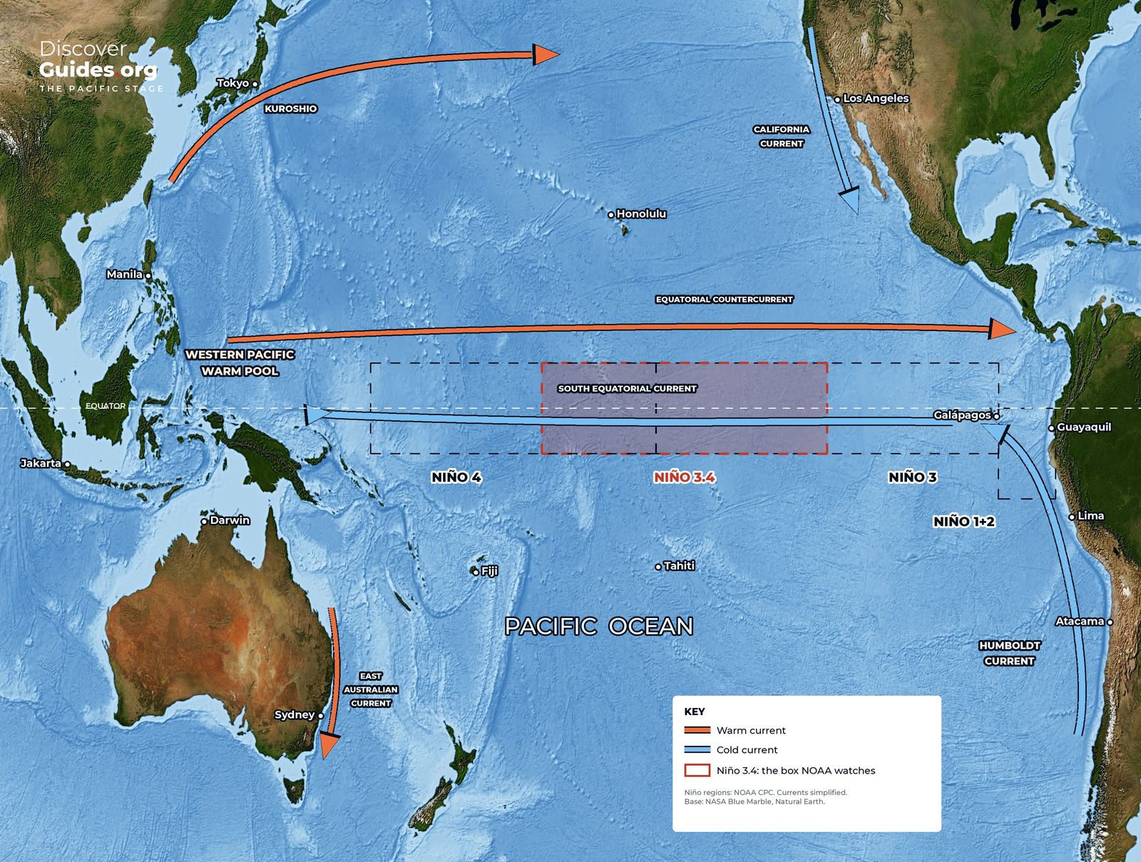
In an ordinary year, the trade winds blow from east to west along the equator. They push sun-warmed surface water towards Asia and Australia, where it piles up into the western Pacific warm pool, some of the warmest open ocean on Earth. The sea surface there even stands slightly higher than off South America.
On the other side of the ocean, the winds drag surface water away from the coast of Peru and Ecuador. Cold, nutrient-rich water rises from below to replace it. This upwelling keeps the eastern Pacific cool and feeds one of the richest fisheries on the planet.
Below the surface, a boundary called the thermocline separates warm upper water from cold deep water. It sits deep in the west and shallow in the east. Above the warm pool, moist air rises into towering rain clouds, flows east high up, and sinks over the cool eastern Pacific. This loop of air is the Walker circulation.
What changes in an El Niño
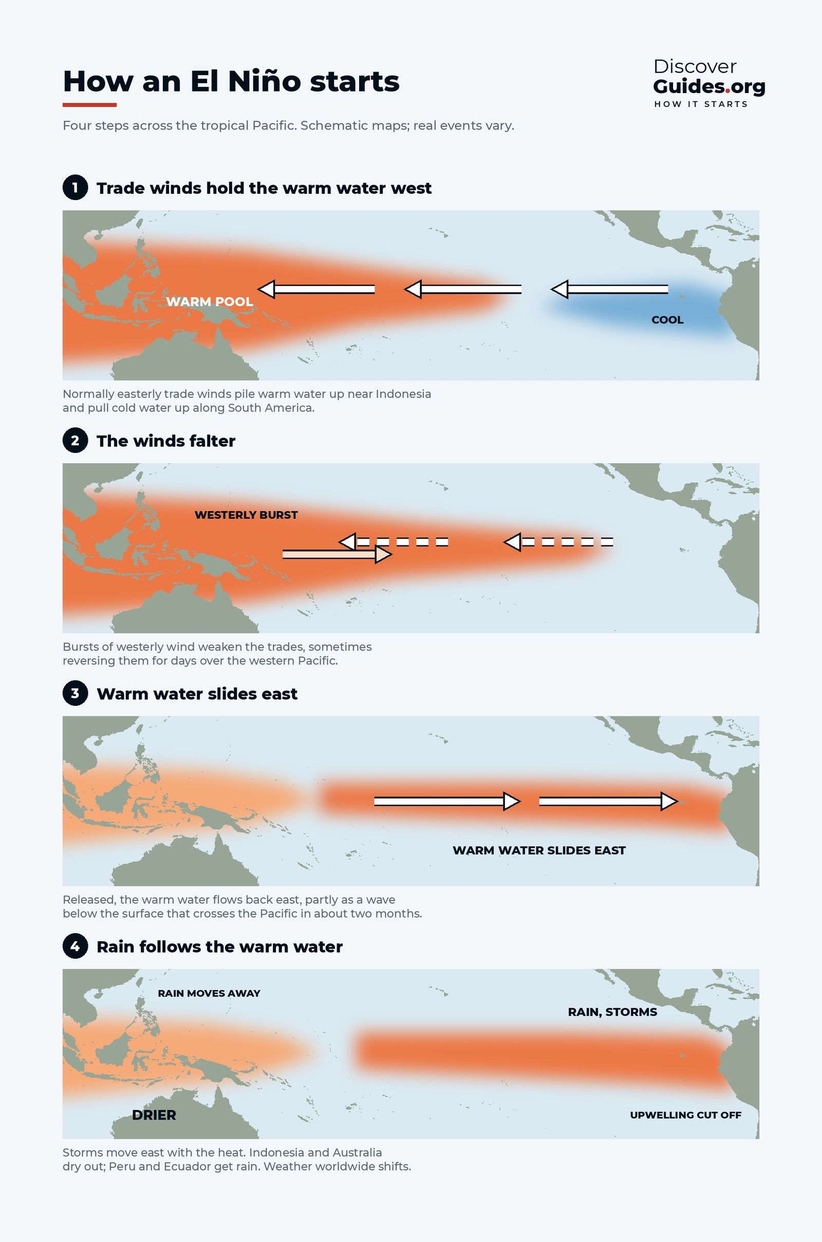
An El Niño begins when the trade winds weaken, sometimes reversing for days in westerly wind bursts over the western Pacific. Released, the warm water from the west sloshes back east, partly as a slow wave below the surface. The thermocline flattens, upwelling off South America brings up warmer water than usual, and the eastern Pacific heats up.
The rain follows the heat. Thunderstorms that normally soak Indonesia and northern Australia move to the central and eastern Pacific. Warmer water weakens the winds further, and weaker winds let the water warm more. This self-reinforcing loop, described by the meteorologist Jacob Bjerknes in 1969, is why a small warming can grow into an event that lasts most of a year. The full sequence is in How Does an El Niño Start?.
| Normal | El Niño | La Niña | |
|---|---|---|---|
| Trade winds | Steady, east to west | Weaker, sometimes reversed | Stronger than usual |
| Warmest water | Western Pacific | Spreads to central and eastern Pacific | Squeezed further west |
| Off Peru and Ecuador | Cool upwelling | Warm, upwelling weakened | Colder than usual |
| Rain over Indonesia | Heavy | Reduced | Heavier |
| Thermocline | Tilted: deep west, shallow east | Flatter | Tilted even more |
Where the name comes from
Fishermen on the coast of Peru noticed long ago that a warm current often appeared around Christmas. They called it El Niño, "the boy", after the Christ child. In most years it was a brief seasonal warming. In some years it was far stronger, lasted for months, and brought heavy rain to the coastal desert while fish catches collapsed.
The atmospheric half of the story was found separately. In the 1920s the British scientist Sir Gilbert Walker, searching for ways to predict India's monsoon, found that air pressure over the Pacific and Indian Oceans rises on one side as it falls on the other. He called it the Southern Oscillation (see Tahiti, Darwin and the See-Saw of the Pacific). Bjerknes later showed that the ocean warming and the pressure see-saw are two sides of the same cycle.
How scientists measure El Niño
Forecasters track the sea-surface temperature in a box of ocean called Niño-3.4, which straddles the equator from 5°N to 5°S and from 170°W to 120°W. An El Niño is declared when the three-month average there runs at least 0.5°C above normal and is expected to stay there for several overlapping seasons.
Since early 2026, NOAA's Climate Prediction Center has used a relative version of this index, called RONI. It compares Niño-3.4 with the average of the whole tropical belt, so that the long-term warming of all the oceans is not mistaken for El Niño. The ±0.5°C thresholds stay the same.
- Weak: roughly +0.5 to +1.0°C
- Moderate: roughly +1.0 to +1.5°C
- Strong: about +1.5°C and above
- Very strong: about +2.0°C and above, the events often called "super El Niños"
These bands are a common shorthand rather than strict rules, and strength in the ocean does not translate neatly into damage on land. A moderate El Niño can still bring a severe drought to one region, while a very strong one may miss another.
Why the whole world feels it
Shifting the Pacific's biggest thunderstorms by thousands of kilometres changes how heat and moisture are pumped into the upper atmosphere. That bends the jet streams and moves storm tracks far from the tropics. These long-distance links are called teleconnections, and they are why an ocean change near the equator can mean a wetter winter in the southern United States, a weaker monsoon in India or drought in southern Africa. Regional patterns are mapped in What El Niño Means for Weather Around the World.
El Niño also lifts global temperature for a while, because the warm Pacific releases heat into the air. Many of the hottest years on record came during or just after an El Niño.
As of NOAA's October 2026 update, a strong El Niño is under way and forecasters give a high chance that it becomes one of the strongest on record. The latest is tracked in The 2026-27 Super El Niño: What We Know So Far, and the full story, from the physics to the great events of the past, is in the book Discover El Niño.
Questions
What is El Niño in simple terms?
El Niño is a natural warming of the surface of the central and eastern tropical Pacific Ocean that happens every few years. The trade winds weaken, warm water spreads east and rainfall patterns shift, which changes weather in many parts of the world.
How often does El Niño happen?
El Niño and La Niña return on average every two to seven years. A typical El Niño lasts about 9 to 12 months, usually peaking between November and January.
What is the difference between El Niño and ENSO?
ENSO, the El Niño-Southern Oscillation, is the whole cycle: El Niño (warm phase), La Niña (cool phase) and neutral conditions. El Niño is one phase of it.
Why is it called El Niño?
Peruvian fishermen named the warm current that often appeared around Christmas El Niño, "the boy", after the Christ child.
Is El Niño caused by climate change?
No. El Niño is a natural cycle that has been recorded for centuries. Scientists are studying how a warming climate may change its strength and its effects, and a warmer world adds to the heat of every El Niño year.

