At a glance
Everything on this page is as of NOAA's October 2026 update, the ENSO Diagnostic Discussion issued by the Climate Prediction Center on 8 October 2026. The next update is due on 12 November 2026. Outlooks change from month to month, so treat the numbers below as a snapshot, not a final verdict.
Where things stand
NOAA has an El Niño Advisory in force, meaning El Niño conditions are observed and expected to continue. The event strengthened further in September. Sea-surface temperatures were more than 4°C above normal in parts of the eastern equatorial Pacific, and the main indices all rose:
- Niño-3.4 (central-east Pacific): about +2.1°C for the latest month
- Niño-3 (eastern Pacific): about +3.0°C
- Niño-1+2 (off Peru and Ecuador): about +3.9°C
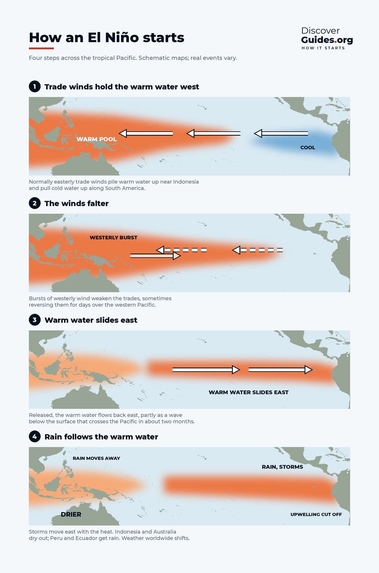
Below the surface, the thermocline was deeper than average and subsurface temperatures were well above normal, which means a large store of warm water was still feeding the surface. The atmosphere had fully joined in: westerly wind anomalies near the surface, enhanced thunderstorms over the central and eastern Pacific, suppressed rainfall over Indonesia, and a strongly negative Southern Oscillation Index. That ocean-air coupling is what turns a warm patch into a self-sustaining El Niño, as explained in How Does an El Niño Start?.
How it grew, month by month
The maps at the top of this page show the Pacific from April to October 2026. In April the equator was near normal, with warmth hugging the coast of South America. By June a warm tongue reached west from Ecuador. By August and September it had become a long band of deep red and purple, more than 3°C above normal across much of the eastern Pacific.
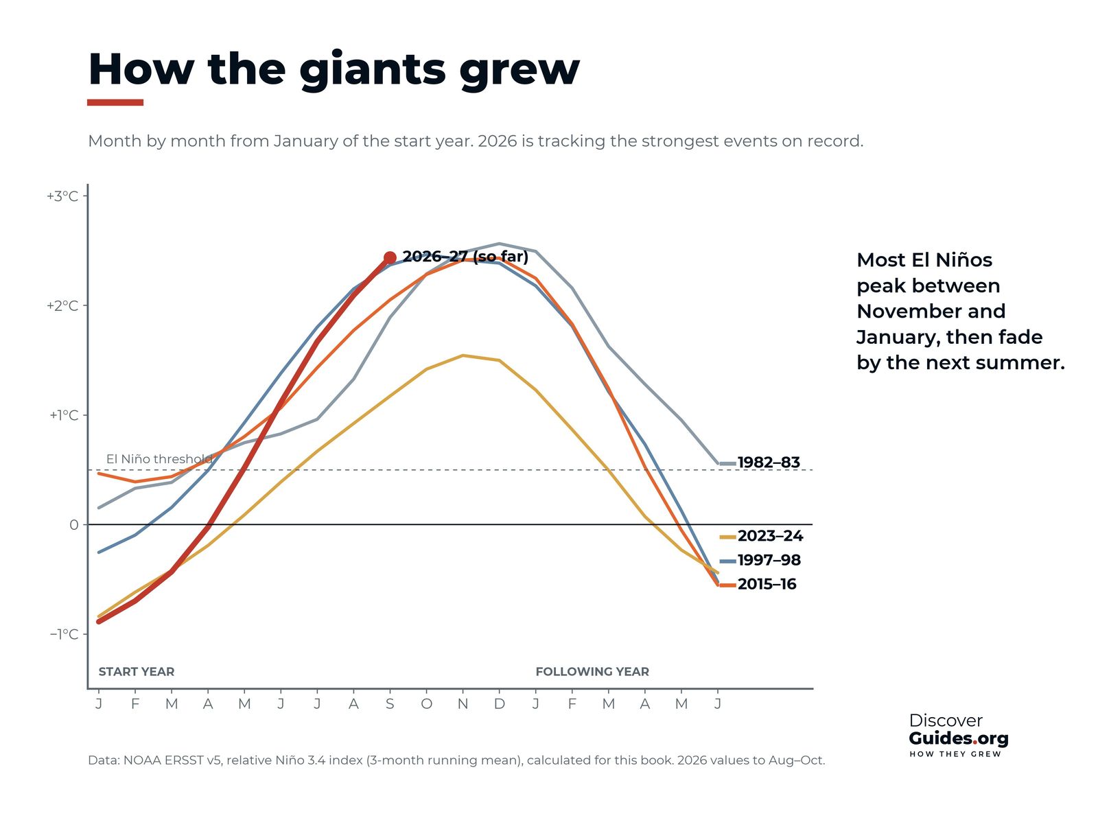
The book's own monthly calculation of the relative Niño-3.4 index (from NOAA's ERSST v5 sea temperatures) tells the same story in numbers: about 0.0°C in April, +0.5°C in May, +1.1°C in June, +1.7°C in July, +2.1°C in August and +2.4°C in September. That pace, about half a degree a month through the northern summer, matched or beat the fastest of the past giants.
How it compares with the giants
Only a handful of El Niños since reliable records began have reached "very strong" levels: 1972-73, 1982-83, 1997-98 and 2015-16 are the best known. The chart above shows that 2026 tracked at or above the three giants plotted there (1982-83, 1997-98 and 2015-16) through September, ahead of the usual calendar. The 2023-24 event, which helped make 2024 the warmest year on record, peaked far lower.
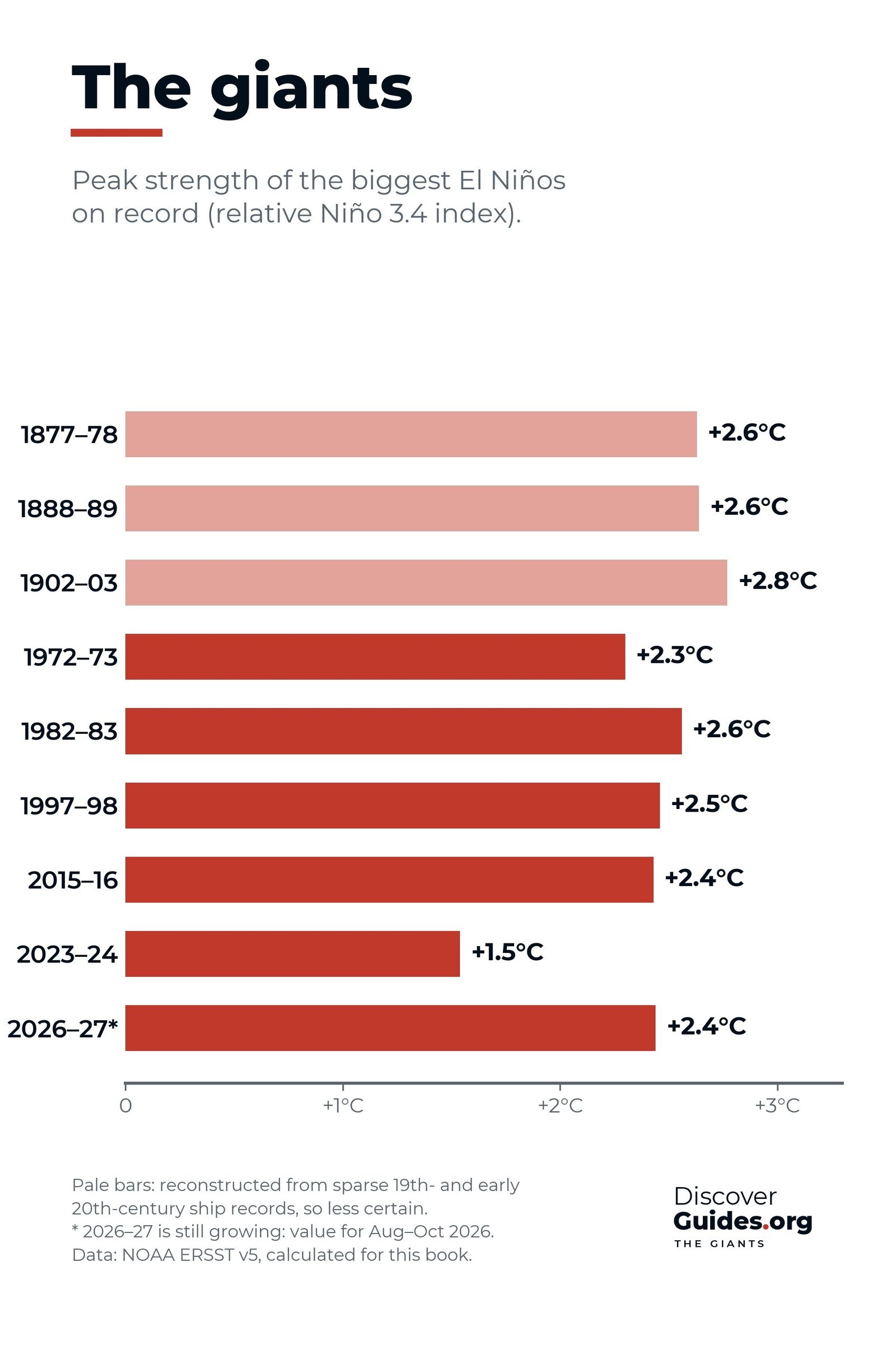
Different datasets and index versions rank the giants slightly differently, so close calls between events should be read with care. What is not in doubt is the direction of travel. NOAA defines a historic event as a three-month relative Niño-3.4 value of +2.5°C or more, which would exceed every El Niño since 1950. As of the October update, NOAA put the chance of reaching that level at 54% for September-November, 83% for October-December and 70% for November-January. In September, NOAA had already given more than a 90% chance of a very strong event. The giants of the more distant past, such as the Great El Niño of 1877-78, are compared in The Strongest El Niños in History, Ranked.
What forecasters expect next
NOAA expects El Niño to keep strengthening through the end of 2026, with a strong-to-very strong El Niño likely through January-March 2027. In its August 2026 update the World Meteorological Organization gave a nearly 100% likelihood that El Niño would persist through February 2027, and said the event could become stronger than any since its monitoring began.
If 2026-27 follows the usual life cycle, the ocean will peak between November and January and weaken through the northern spring. Strong events often swing into La Niña afterwards, but that is a question for forecasts made in 2027. How those forecasts are built, and how to read them, is in How El Niño Forecasts Are Made.
What it could mean for weather
El Niño shifts the odds rather than writing the forecast. For December to February, a strong event typically means a wetter, stormier winter across the southern United States, a milder winter in western Canada, rain on the coasts of Ecuador and Peru, and drier conditions in Indonesia, northern Australia, southern Africa and northern South America. The WMO has stressed that the strength of an El Niño does not translate directly into the size of its impacts in any one region.
Some effects are already being felt. By early September the WMO reported that Peru had declared a state of emergency for flooding and landslides, and that Panama had declared a national emergency to fund preventive measures.
SafetyEl Niño raises the risk of floods, landslides, drought, wildfire and extreme heat in many regions. Follow your national weather service and local emergency warnings, which are based on the daily forecast for your area, not on the El Niño outlook alone.
Global temperature is the other thing to watch. Because the warmth of an El Niño reaches the global average with a delay of several months, the largest effect of an event peaking in late 2026 would fall in 2027. The WMO's Secretary-General has said it would not be surprising if the 2024 record were broken. The link is explained in Does El Niño Cause Record Heat?.
For live data, NOAA publishes its ENSO Diagnostic Discussion on the second Thursday of each month. The book Discover El Niño puts the 2026-27 event in context with 150 years of El Niños, dated "as of" its latest update.
Questions
Is 2026 a super El Niño?
As of NOAA's October 2026 update, the El Niño was strong and still strengthening, with a strong-to-very strong event likely through January-March 2027. Events at that level are often called super El Niños. NOAA gave an 83% chance of a historic event (relative Niño-3.4 of +2.5°C or more) for October-December 2026.
When will the 2026-27 El Niño peak?
Most El Niños peak between November and January. NOAA expects this one to keep strengthening through the end of 2026.
How strong is the 2026 El Niño compared with 1997-98?
Through September 2026 it was tracking at or above the 1982-83, 1997-98 and 2015-16 events on the relative Niño-3.4 index. Its final peak will only be known in early 2027.
Will 2027 be the hottest year on record?
It is possible but not certain. Global temperature usually peaks a few months after an El Niño, so an event peaking in late 2026 would have its biggest effect in 2027. The WMO has said a new record would not be surprising.
When is NOAA's next El Niño update?
NOAA's Climate Prediction Center issues its ENSO Diagnostic Discussion on the second Thursday of each month. After the 8 October 2026 update, the next was scheduled for 12 November 2026.