At a glance
Both phases belong to the El Niño-Southern Oscillation, or ENSO. The cycle swings between a warm phase (El Niño), a cool phase (La Niña) and a neutral middle. The difference between them starts with one thing: how hard the trade winds blow across the equatorial Pacific.
The short version
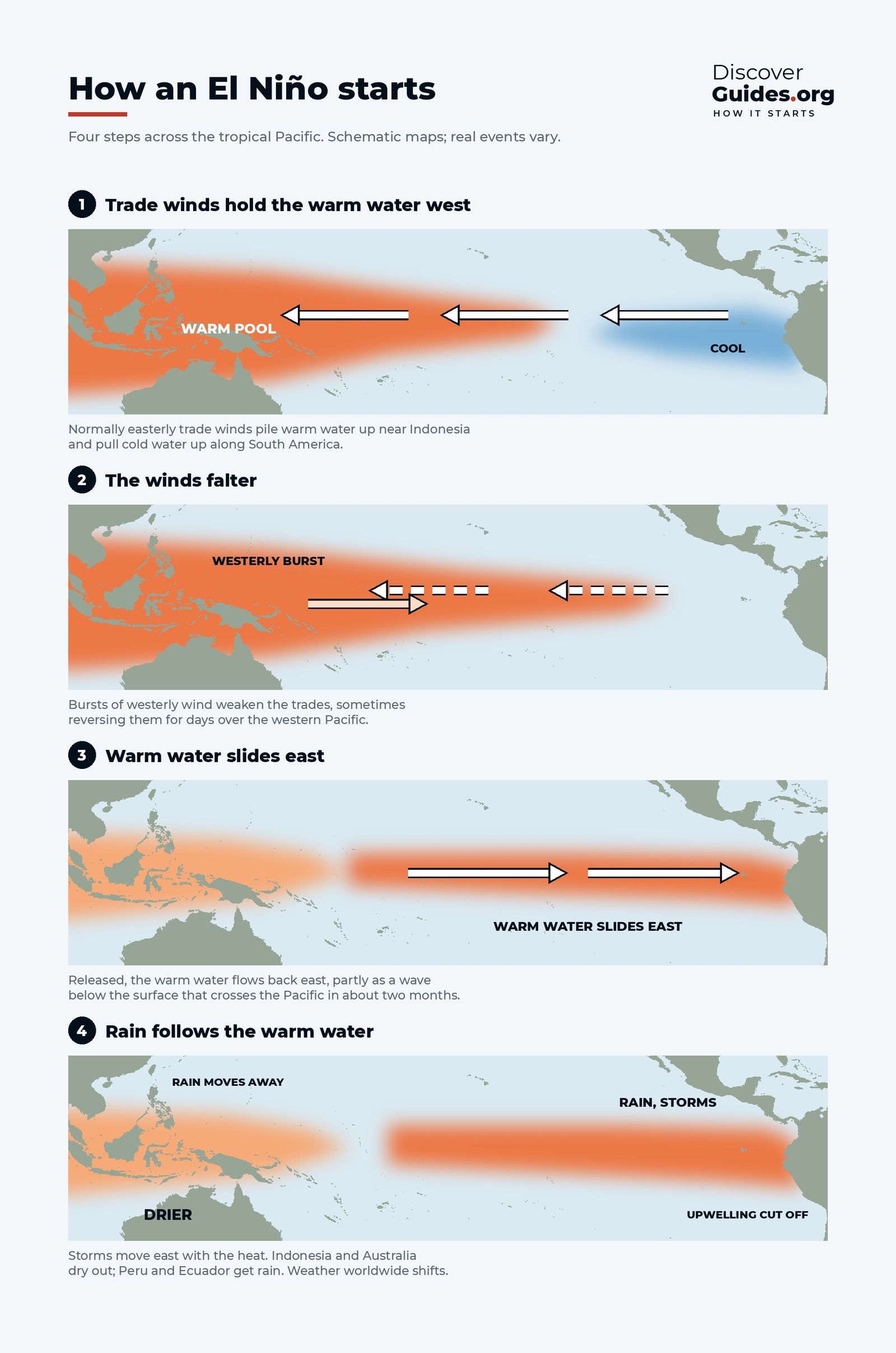
In El Niño, the trade winds weaken. Warm water that normally sits in the western Pacific spreads east, the cold upwelling off South America is muted, and the big rain clouds move from Indonesia towards the central Pacific.
In La Niña, the trade winds strengthen. Warm water is pushed even further west, cold water wells up along the equator in the east, and rain intensifies over Indonesia and northern Australia. La Niña is, in effect, an exaggerated version of normal conditions. For the mechanics of each phase, start with What Is El Niño?.
| El Niño | La Niña | |
|---|---|---|
| Trade winds | Weaker, sometimes reversed | Stronger |
| Central and eastern Pacific | Warmer than normal | Cooler than normal |
| Air pressure (Tahiti minus Darwin) | Falls: negative SOI | Rises: positive SOI |
| Indonesia and northern Australia | Often drier | Often wetter |
| Peru and Ecuador coast | Heavy rain, warm sea | Dry, cold sea |
| Southern United States in winter | Often wetter and cooler | Often drier and warmer |
| Atlantic hurricanes | Usually suppressed | Usually favoured |
| Global temperature | Pushed up for a while | Pulled down for a while |
| Typical length | 9-12 months | 1-3 years |
Why they are not perfect mirror images
La Niña is not simply El Niño with the sign flipped. The two phases differ in rhythm. El Niño tends to build quickly, peak around the turn of the year and collapse by the following summer. La Niña is usually weaker at its peak but more stubborn, often returning for a second or even third winter. From 2020 to 2023, La Niña lasted through three northern winters in a row, the event known as the "triple dip".
Strong El Niños are often followed by La Niña. When the warm water drains away from the equator at the end of an El Niño, the ocean can overshoot into the cool phase. That happened after the giants of 1997-98 and 2015-16, and after the El Niño of 2009-10, which handed over to the La Niña shown at the top of this page.
Their footprints differ too. El Niño's warmth is concentrated in the central and eastern Pacific; La Niña's cold tongue often stretches further west, closer to the date line. That changes which regions feel each phase most strongly.
La Niña in action: 2010-11
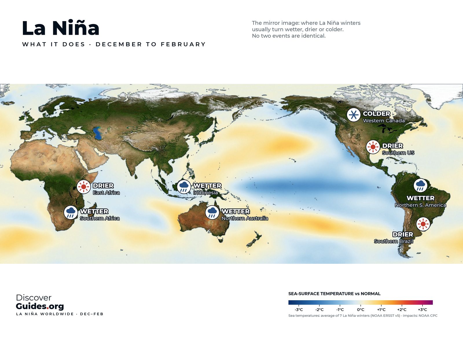
The map at the top of this page shows the Pacific in December 2010, in the middle of a La Niña that Australia's Bureau of Meteorology describes as one of the strongest on record. A long band of cooler-than-normal water runs along the equator, while the western Pacific and the seas around northern Australia are warmer than usual.
The results were severe. Flooding from late November 2010 to mid-January 2011 was among the most significant in Australia's recorded history, including deadly river and flash floods in south-east Queensland. Across the country, 2010 and 2011 together were the wettest two-year period on record, with 1,408 mm of rain. So much rain fell on land, much of it in Australia, that global sea level briefly dropped by a few millimetres.
On the other side of the Pacific, Colombia suffered prolonged floods, and Texas went through one of the worst single-year droughts in its history in 2011. Both fit La Niña's typical pattern.
Who prefers which?
There is no "good" or "bad" phase. Each brings drought to some regions and rain to others. For example, El Niño tends to dry out Indonesia, northern Australia and southern Africa in the southern summer, while La Niña tends to soak them. The southern United States often gets the reverse: a wet winter in El Niño, a dry one in La Niña.
- Australia: El Niño raises the risk of drought and bushfire in the east; La Niña raises the risk of flooding.
- Peru and Ecuador: El Niño brings rain to the coastal desert and warm water that drives away anchoveta; La Niña keeps the coast dry and the sea cold. More in El Niño in Peru.
- Atlantic hurricane season: La Niña reduces the wind shear that tears storms apart, so busy seasons are more likely. El Niño usually does the opposite. See El Niño, Hurricanes and Typhoons.
- Southern Africa: El Niño summers are often dry, La Niña summers often wet.
These are tendencies, not guarantees. Other climate patterns, such as the Indian Ocean Dipole, and ordinary weather can overwhelm the ENSO signal in any one season.
How each phase is declared
Both are measured the same way. NOAA's Climate Prediction Center watches the relative sea-surface temperature of the Niño-3.4 region. When the three-month average runs at least 0.5°C above normal and the atmosphere responds, it is El Niño; at least 0.5°C below, La Niña. Australia's Bureau of Meteorology also tracks the Southern Oscillation Index, where sustained values below -7 often indicate El Niño and above +7 are typical of La Niña.
As of NOAA's October 2026 update, the Pacific is firmly in the El Niño phase, and a strong-to-very strong event is likely through January-March 2027. Both phases, their history and their effects are covered in depth in Discover El Niño.
Questions
What is the main difference between El Niño and La Niña?
El Niño is the warm phase of the Pacific cycle: the trade winds weaken and the central and eastern tropical Pacific warms. La Niña is the cool phase: the trade winds strengthen and the same waters cool.
Which is worse, El Niño or La Niña?
Neither. Each brings drought to some regions and floods to others. El Niño tends to dry Indonesia and eastern Australia, while La Niña raises flood risk there and drought risk in the southern United States.
Does La Niña always follow El Niño?
No, but it often does after strong events. La Niña followed the El Niños of 1997-98, 2009-10 and 2015-16.
How long does La Niña last?
La Niña typically lasts one to three years, longer than El Niño. The 2020-23 event lasted through three northern winters.