At a glance
Jet streams are narrow bands of strong wind high in the atmosphere, roughly 9 to 16 km up, where air masses of very different temperature meet. Weather systems ride along them. Shift a jet stream a few hundred kilometres north or south for a season and you shift where the rain falls, where the cold air goes and where the mild air settles.
The two main jets
Each hemisphere has two main jet streams. The polar jet runs along the boundary between cold polar air and milder mid-latitude air. The subtropical jet runs higher, near the poleward edge of the tropics, where air that rose at the equator flows out and turns east. In winter, when temperature contrasts are greatest, both are at their strongest.
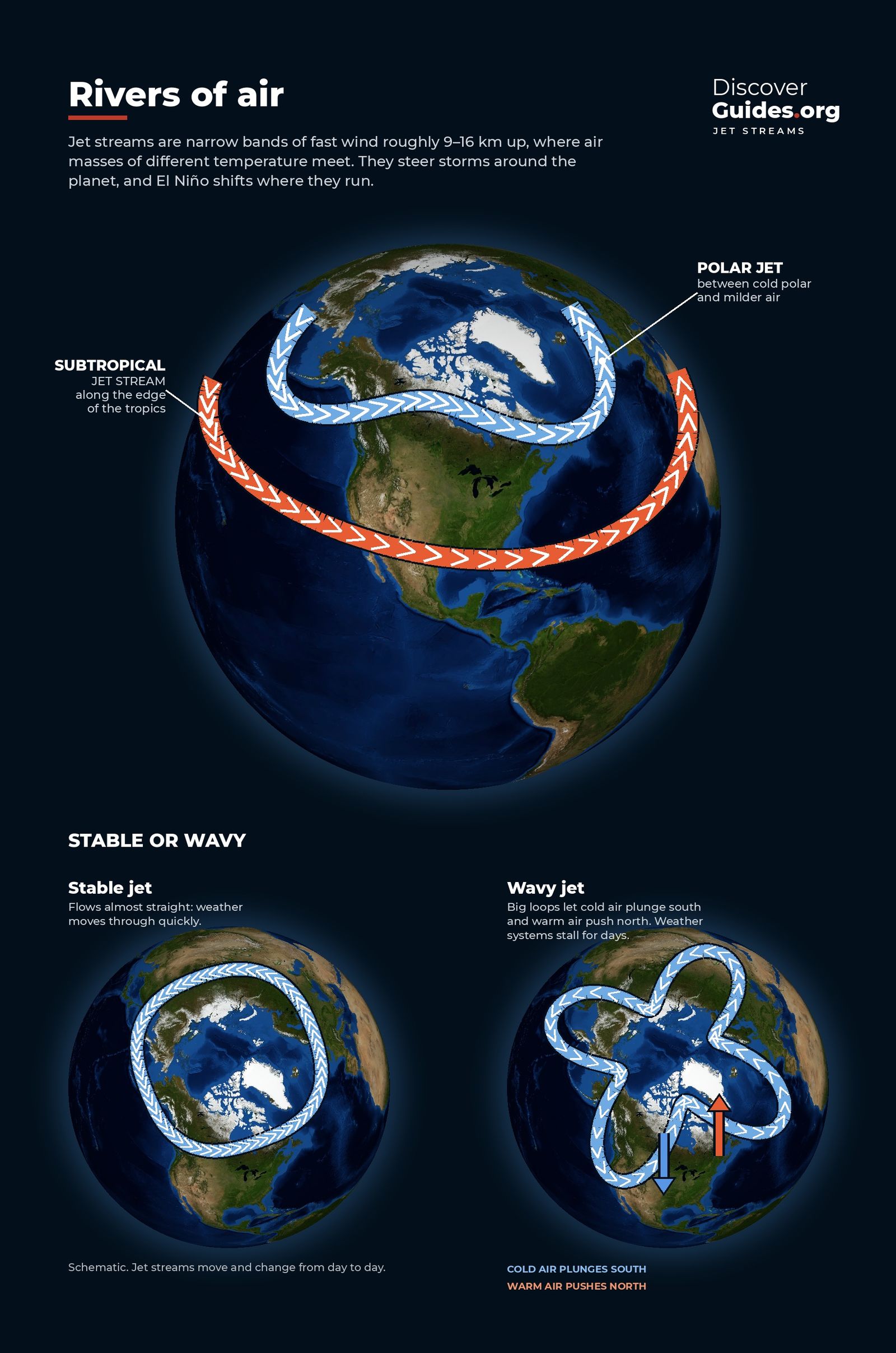
Neither jet runs in a neat circle. They meander in large waves, and the shape of those waves decides the weather beneath them. That is where El Niño comes in.
From tropical thunderstorms to mid-latitude winds
During an El Niño, the warmest water in the tropical Pacific shifts east, and the giant clusters of thunderstorms that normally sit over Indonesia follow it towards the central and eastern Pacific. Those storms release enormous amounts of heat as water vapour condenses into rain, and they push air high into the atmosphere.
The extra heating in a new place acts like a rock in a stream. It strengthens the subtropical jet above it and sends a train of large atmospheric waves arcing towards the poles and back. These waves change the pattern of high and low pressure thousands of kilometres away. Scientists call such long-distance links teleconnections. For how the planet's winds fit together in the first place, see How the Planet's Winds Work.
The El Niño winter pattern
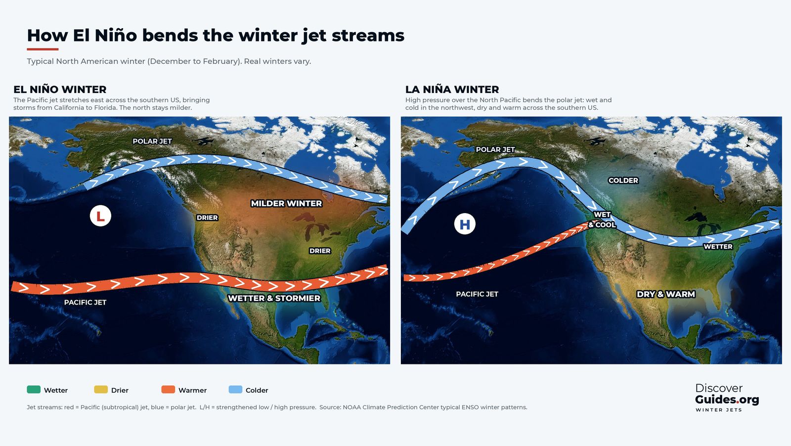
The left-hand map at the top of this page shows the typical result for a North American winter (December to February):
- A stronger, longer Pacific jet. The subtropical jet stretches east across the Pacific and runs over the southern United States, from California to Florida.
- A deeper low in the North Pacific. The Aleutian low strengthens, steering storms into the jet's path.
- A wetter, stormier south. More storms reach southern California, the Gulf Coast and Florida. Winter across the southern states is often wetter and cooler than normal.
- A milder north. With the polar jet pushed north, western Canada and the northern United States often see a milder winter, and parts of the Ohio Valley and northern tier can be drier.
This is the classic pattern behind El Niño's reputation for wet winters in California. Atmospheric rivers can ride the strengthened Pacific jet straight into the coast, as explained in El Niño and California.
The La Niña winter pattern
La Niña tends to do the opposite, shown on the right-hand map. A ridge of high pressure builds over the North Pacific, and the polar jet loops north around it and then dives south-east into North America. The Pacific Northwest and the Ohio Valley are often wetter; western Canada and the northern Plains colder; the southern United States drier and warmer. A drier southern tier in La Niña winters raises the risk of drought there, as in Texas in 2011. The two phases are compared in El Niño vs La Niña.
| Winter pattern | El Niño | La Niña |
|---|---|---|
| Pacific (subtropical) jet | Stronger, extended east over the southern US | Weaker |
| Polar jet | Further north, flatter | Wavier, dipping into the northern US |
| North Pacific pressure | Deeper Aleutian low | Strong ridge of high pressure |
| Southern United States | Often wetter and cooler | Often drier and warmer |
| Western Canada and northern US | Often milder | Often colder |
Beyond North America
The same mechanism works elsewhere, but the signal is clearest over the Pacific and the Americas, which lie directly downstream of the shifted thunderstorms. In the Southern Hemisphere, El Niño also changes the subtropical jet, which contributes to wetter conditions in southern Brazil and Uruguay. Over Europe the effect is weak and easily drowned out by other patterns, such as the North Atlantic Oscillation, so El Niño offers little guidance for a European winter.
El Niño's influence on the jets also matters for tropical storms. Stronger upper-level westerly winds over the Caribbean and tropical Atlantic increase the wind shear that tears developing hurricanes apart, which is one reason El Niño years usually have quieter Atlantic seasons. More in El Niño, Hurricanes and Typhoons.
Why every El Niño winter is different
The very strong El Niño of 2015-16 is a well-known example. Many people in California expected a drenching winter. Northern California did receive near-normal rain and snow, but southern California, where the El Niño signal is usually strongest, stayed drier than normal, and the state's drought was not broken that year. Other recent El Niño winters have delivered much closer to the textbook pattern.
The maps above show the typical pattern, not a guarantee. The jet streams respond to many influences at once: the Arctic, the Atlantic, the stratosphere and day-to-day weather. El Niño loads the dice, and a strong event loads them more, but any one winter can still surprise. Seasonal outlooks from national weather services already take El Niño into account and are the best guide for a specific place.
The full set of jet stream graphics, including the stable and wavy jet and the Walker circulation, is in the book Discover El Niño.
Questions
How does El Niño affect the jet stream?
El Niño moves the tropical Pacific's biggest thunderstorms east. The extra heating strengthens the subtropical (Pacific) jet and stretches it east across the southern United States in winter, while the polar jet tends to stay further north.
Does El Niño mean a wet winter in California?
It raises the odds, especially in southern California, because the strengthened Pacific jet steers more storms into the region. It is not guaranteed: some El Niño winters have been close to normal.
Does El Niño mean a mild winter?
Often in western Canada and the northern United States, where the polar jet tends to stay further north. The southern United States is more often wetter and cooler than normal.
Does El Niño affect European winters?
Only weakly. Other patterns, such as the North Atlantic Oscillation, usually matter more for Europe, so El Niño gives little guidance for a European winter.


