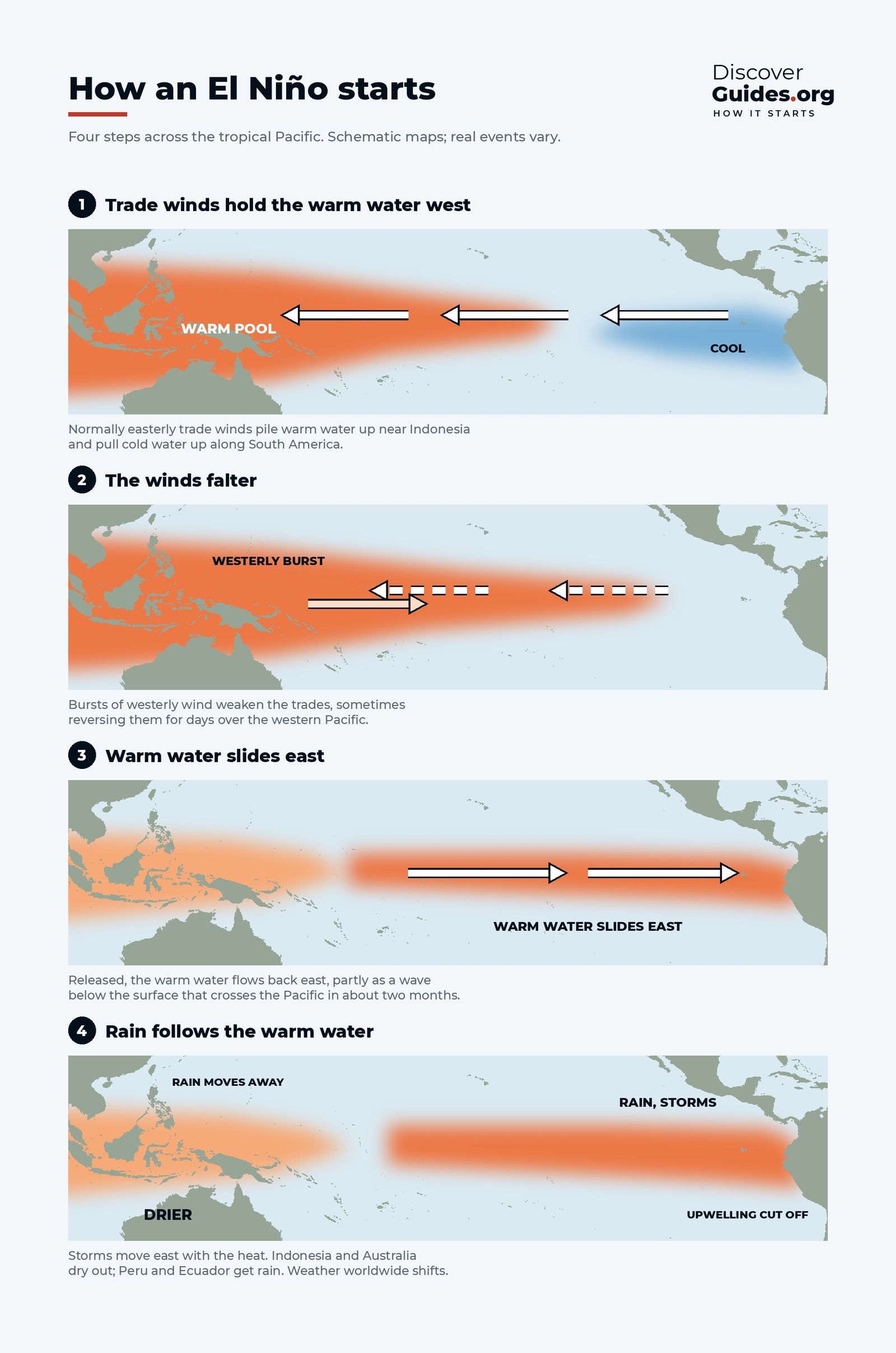
At a glance
To understand how an El Niño starts, begin with what holds it back. In normal conditions the trade winds blow from east to west along the equator, piling warm water up in the western Pacific and drawing cold water to the surface off South America. As long as those winds hold, the warm pool stays in the west. An El Niño is what happens when they let go.
Step 1: the warm water is loaded
Years of steady trade winds build up a large volume of warm water in the western Pacific and along the equator. Scientists call this a recharged ocean: the thermocline, the boundary between warm surface water and cold deep water, sits unusually deep. A recharged Pacific does not guarantee an El Niño, but it supplies the fuel. Without enough warm water in reserve, an event tends to fizzle.
Step 2: the winds falter
The trigger usually comes from the atmosphere. Over the western Pacific, bursts of westerly wind can blow for days to a couple of weeks, against the usual direction of the trades. These westerly wind bursts are often linked to passing waves of tropical thunderstorms, such as the Madden-Julian Oscillation, or to pairs of tropical cyclones spinning on either side of the equator.
A single burst does not make an El Niño. A series of them, arriving while the ocean is recharged, can.
Step 3: the hidden wave
Each strong burst pushes warm surface water east and presses the thermocline down. That depression travels east along the equator as a downwelling Kelvin wave. It is almost invisible at the surface, raising sea level by only a few centimetres, but it pushes the thermocline down by tens of metres. It crosses the Pacific in roughly two months.
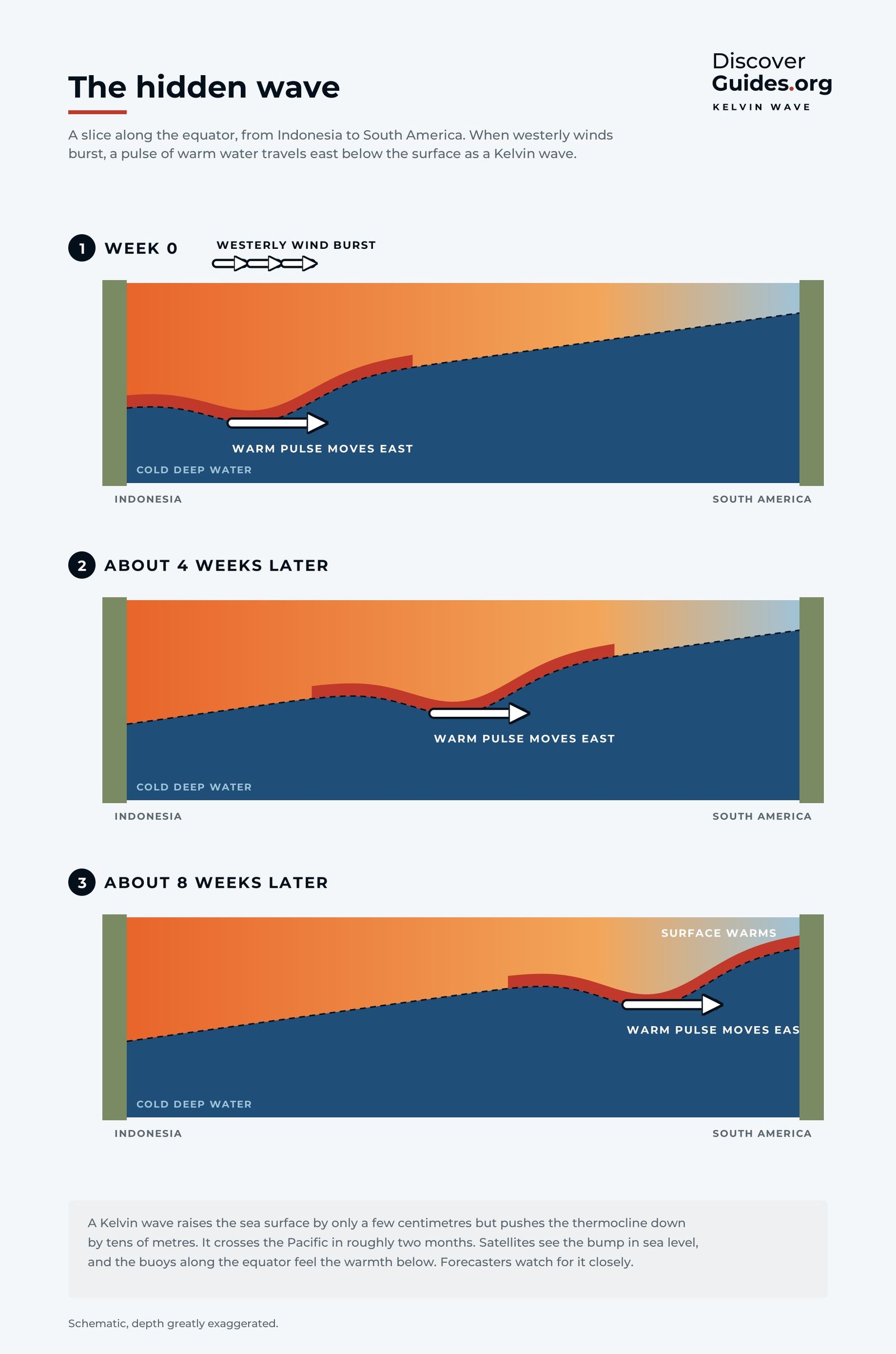
When the wave reaches the eastern Pacific, the deeper thermocline means that upwelling off Peru and Ecuador now brings up warmer water than usual. The sea surface heats up from below. Satellites see the bump in sea level as the wave travels, and moored buoys along the equator feel the warmth underneath, which is why forecasters track Kelvin waves closely.
Step 4: the ocean and air lock together
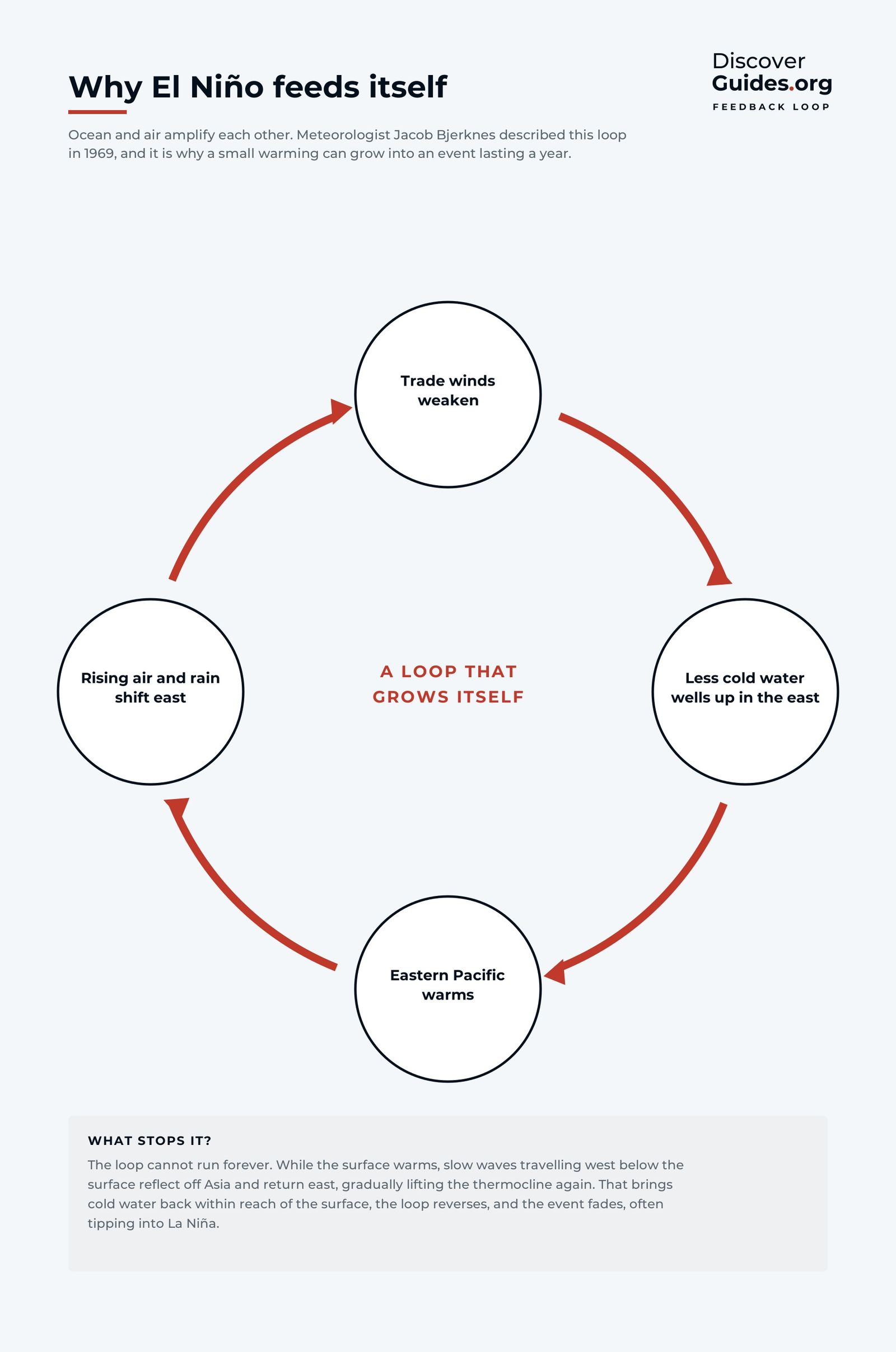
Once the eastern Pacific begins to warm, a feedback loop takes over. Warmer water in the east reduces the temperature difference across the Pacific that drives the trade winds. Weaker trades allow less cold water to well up, so the east warms further. Rising air and rain shift east with the warm water, which weakens the trades again.
The Norwegian-American meteorologist Jacob Bjerknes described this loop in 1969, and it is still known as the Bjerknes feedback. It explains why a modest warming can grow into an event that lasts a year and changes weather around the world.
Why spring is the critical season
Most El Niños begin in the northern spring, grow through the summer and autumn, and peak between November and January. Spring is when the east-west temperature contrast across the Pacific is naturally at its weakest, so the system is easiest to tip. It is also when forecasts are least reliable, a problem known as the spring predictability barrier. A few weeks of wind can decide whether a promising warm-up becomes an El Niño or fades. How forecasters handle that uncertainty is covered in How El Niño Forecasts Are Made.
What forecasters watch for in an early El Niño
- Above-average warm water volume along the equator
- Repeated westerly wind bursts over the western Pacific
- Downwelling Kelvin waves showing up in sea level and buoy data
- Warming at the surface in the Niño-3.4 region
- A falling Southern Oscillation Index and rain shifting east of the date line
Not every start succeeds
The ingredients can line up and still fail. In early 2014 the Pacific held a large store of warm water, strong westerly bursts sent a powerful Kelvin wave east, and many forecasters expected an El Niño, possibly a big one. Then the westerly bursts stopped, the trade winds recovered, and the atmosphere never coupled with the ocean. The warm water lingered, and the full El Niño arrived a year later, in 2015, growing into one of the strongest on record.
The lesson for forecasters is that the ocean alone is not enough. An El Niño needs the winds to keep cooperating for months, which is why forecasts speak in probabilities rather than certainties.
What stops it
The loop cannot run forever. While the surface warms, the same wind changes send slower waves west below the surface. These Rossby waves reach the western edge of the Pacific, reflect, and return east as upwelling Kelvin waves that lift the thermocline again. At the same time, warm water drains away from the equator towards higher latitudes. Cold water comes back within reach of the surface, the feedback turns around, and the event fades, often tipping into La Niña. The differences between the two phases are in El Niño vs La Niña.
The 2026 event followed this script closely: the equatorial Pacific was near normal in April and warmed fast through the northern summer, as tracked in The 2026-27 Super El Niño. The full mechanism, with many more diagrams, is in Discover El Niño.
Questions
What triggers an El Niño?
Usually a combination of a recharged ocean, with plenty of warm water stored along the equator, and a series of westerly wind bursts over the western Pacific. The bursts send warm water east as Kelvin waves, and the ocean-air feedback loop amplifies the warming.
What is a Kelvin wave in El Niño?
A downwelling Kelvin wave is a pulse of warm water that travels east along the equator below the surface. It raises sea level by only a few centimetres but pushes the thermocline down by tens of metres, and it crosses the Pacific in roughly two months.
What is the Bjerknes feedback?
It is the self-reinforcing loop described by Jacob Bjerknes in 1969: weaker trade winds let the eastern Pacific warm, and a warmer eastern Pacific weakens the trade winds further.
Why do El Niños start in spring?
The east-west temperature contrast across the Pacific is weakest in the northern spring, so the system is easiest to tip. Events then grow through summer and autumn and usually peak between November and January.


