At a glance
A monsoon is a seasonal reversal of the winds: as the land heats faster than the sea, moist ocean air is drawn inland and wrung out as rain. But the monsoon's engine room is not only over the land. It is connected, through the great east-west loop of the Walker circulation, to the temperature of the tropical Pacific (see The Walker Circulation).
How El Niño weakens the monsoon
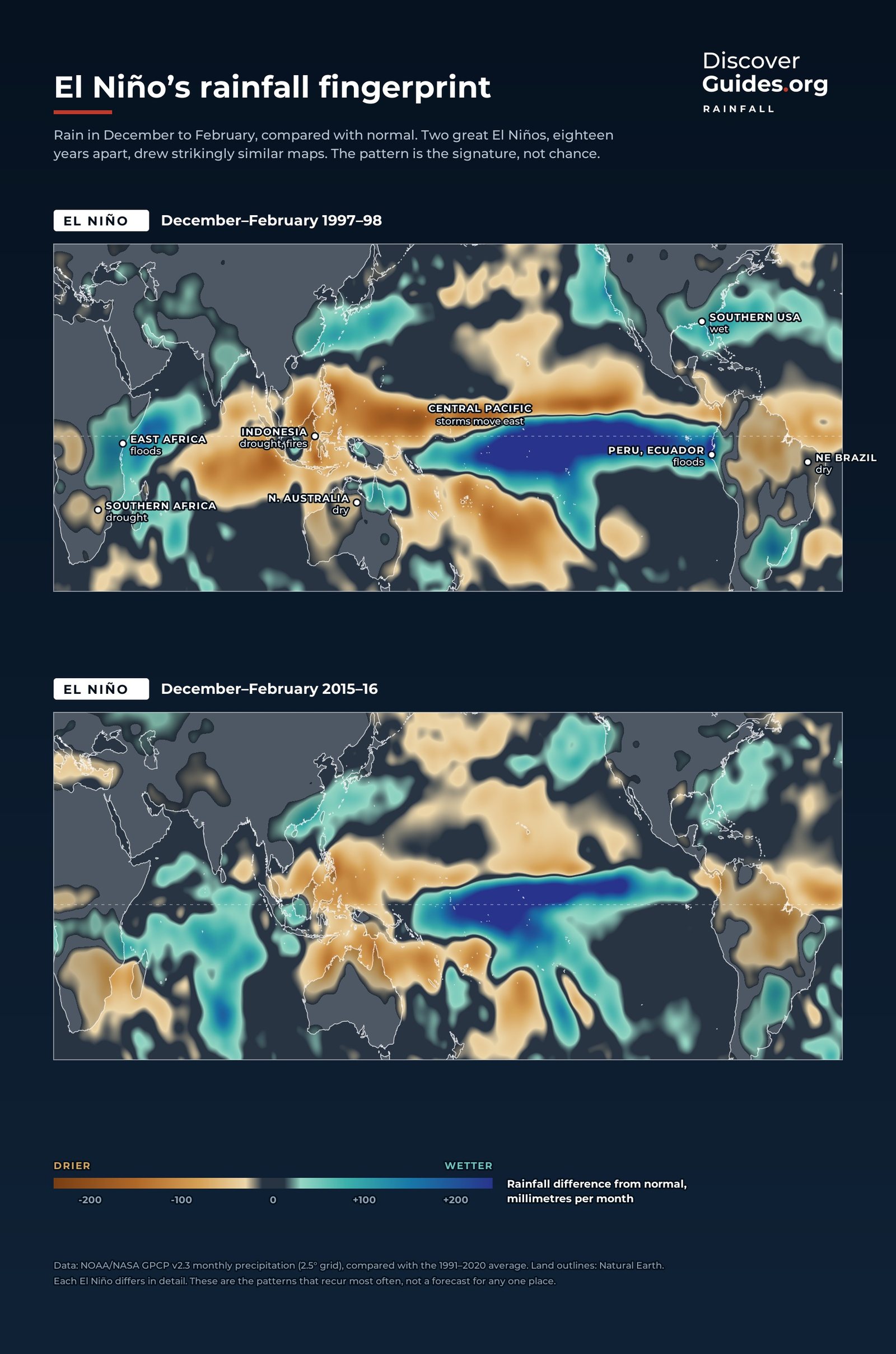
Air that rises in one part of the tropics has to sink somewhere else. In normal years the strongest rising air sits over the warm waters around Indonesia, feeding heavy rain across the Maritime Continent and helping the summer monsoon over South Asia. During El Niño the warmest water and the rising air drift east into the central Pacific. The compensating sinking air, dry and stable, presses down over regions that should be wet.
The result is not a switch but a tilt of the odds. El Niño loads the dice toward a weaker season in South Asia, Indonesia, eastern Australia and southern Africa, and toward a wetter one in parts of East Africa, as the satellite rainfall maps at the top of this page show for the giant winters of 1997-98 and 2015-16.
The forecasters' oldest puzzle
India has watched this link longer than anyone. After the famines of 1877 and 1899, the British appointed Gilbert Walker in 1904 to find a way to forecast the monsoon, and his search led to the discovery of the Southern Oscillation (see Who Discovered El Niño?). Today the India Meteorological Department (IMD) still issues its long-range monsoon forecast each spring with one eye on the Pacific.
The link is strong but not reliable. A study published in Science in 2006 by K. Krishna Kumar, Martin Hoerling and colleagues examined 132 years of Indian rainfall. Every severe drought in that record came with an El Niño, yet many El Niños brought no severe drought. El Niños with the warmest water in the central Pacific were more effective at starving the monsoon than events centred near South America (see El Niño Modoki).
The 2026 monsoon
A weak El Niño formed in June 2026 and was strong by the end of the season. The IMD recorded 759.4 mm of rain between June and September, 87 per cent of the long-period average: the fourth lowest since 2001 and the thirteenth lowest since 1901. The shortfall was uneven.
| Region | Rainfall | Share of average |
|---|---|---|
| Northwest India | 553.0 mm | 94% |
| Central India | 952.8 mm | 97% |
| East and Northeast India | 1,016.3 mm | 74% |
| South Peninsula | 542.0 mm | 76% |
| All India | 759.4 mm | 87% |
Source: India Meteorological Department, 30 September 2026. For farmers, a few weeks of failure in the wrong place can matter more than the national total. Earlier El Niños left their mark too: India's 2015 monsoon fell 14 per cent short, and August 2023 brought 36 per cent less rain than normal, the driest August since records began in 1901.
The Indian Ocean Dipole
The Indian Ocean has its own version of El Niño, recognised only in 1999. The Indian Ocean Dipole (IOD) is a contrast in sea surface temperature between the western Indian Ocean, near Africa, and the eastern side, near Java and Sumatra. In a positive phase the west is warmer than usual and the east cooler. A positive IOD tends to dry out Indonesia and Australia and drench East Africa. El Niño often helps trigger a positive IOD.
- El Niño plus positive IOD: the highest odds of drought in Indonesia and southern and eastern Australia, and of floods in East Africa.
- El Niño with a neutral IOD: the Pacific acts largely alone, as during India's 2026 monsoon, when the IOD stayed neutral all season.
- Positive IOD without El Niño: still possible, as in 2019, when the dipole grew while the Pacific was close to neutral.
Heat before the rains
El Niño's heat can arrive before the monsoon too. In April 2024, as the 2023-24 El Niño faded, much of South and South-east Asia baked: the WMO reported 45.9 °C in Myanmar, and schools closed in Bangladesh, Myanmar and Thailand (see El Niño and Global Temperature).
Questions
Does El Niño cause drought in India?
It raises the risk. In 132 years of records every severe Indian drought came with an El Niño, but many El Niños brought no severe drought.
How did El Niño affect India's 2026 monsoon?
The IMD recorded 87 per cent of normal June-September rainfall, with East and Northeast India at 74 per cent and the South Peninsula at 76 per cent.
What is the Indian Ocean Dipole?
A contrast in sea temperature between the western and eastern Indian Ocean. Its positive phase tends to dry Indonesia and Australia and bring floods to East Africa. It can amplify or offset El Niño.
Why does El Niño weaken the monsoon?
El Niño moves the Pacific's main rising air east, so dry sinking air settles over South Asia and Indonesia, suppressing rain.


