At a glance
Two flavours of El Niño
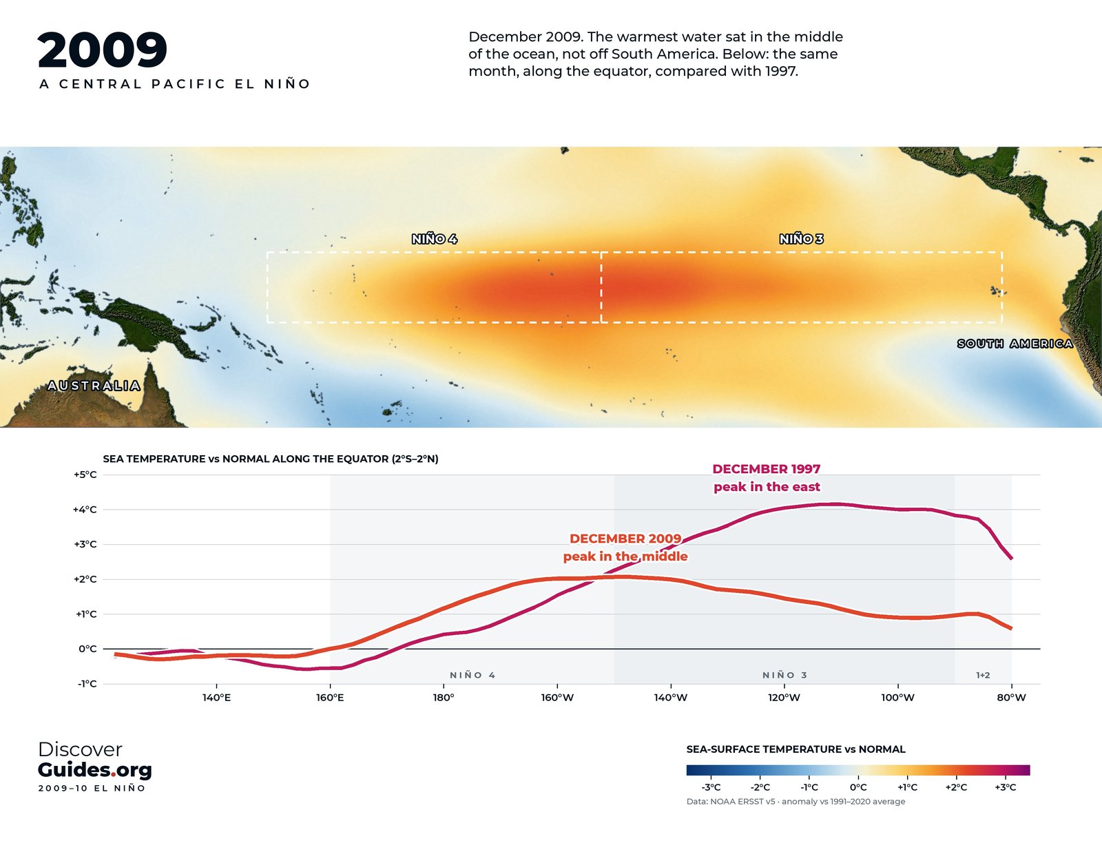
Classic events, like 1982-83 and 1997-98, warm most strongly in the east, near South America. Others peak in the central Pacific around the date line. The Japanese oceanographer Toshio Yamagata coined the name El Niño Modoki, meaning "similar but different", for the 2004 event, and Karumuri Ashok and colleagues applied it more widely in a 2007 paper in the Journal of Geophysical Research.
| Eastern Pacific (classic) | Central Pacific (Modoki) | |
|---|---|---|
| Warmest water | Off Peru and Ecuador | Around the date line |
| Region that warms most | Niño 3 and Niño 1+2 | Niño 4 |
| Examples | 1982-83, 1997-98 | 2004, 2009-10 |
| Atlantic hurricanes | Tend to be suppressed | Linked to more frequent storms (Kim et al., 2009) |
2009-10: the record central Pacific event
A NASA and NOAA study by Tong Lee and Michael McPhaden, published in Geophysical Research Letters in 2010, found that the intensity of central Pacific El Niños had nearly doubled over their study period, and called the event of 2009-10 the strongest central Pacific El Niño observed to date. The map at the top of this page shows why: in December 2009 the warmest water sat in the middle of the ocean, not off South America.
That winter still left a mark far away. Environment and Climate Change Canada's record for the warmest winter in its nationwide series was set in the El Niño winter of 2009-10, and stood until the El Niño winter of 2023-24 beat it by 1.1 °C.
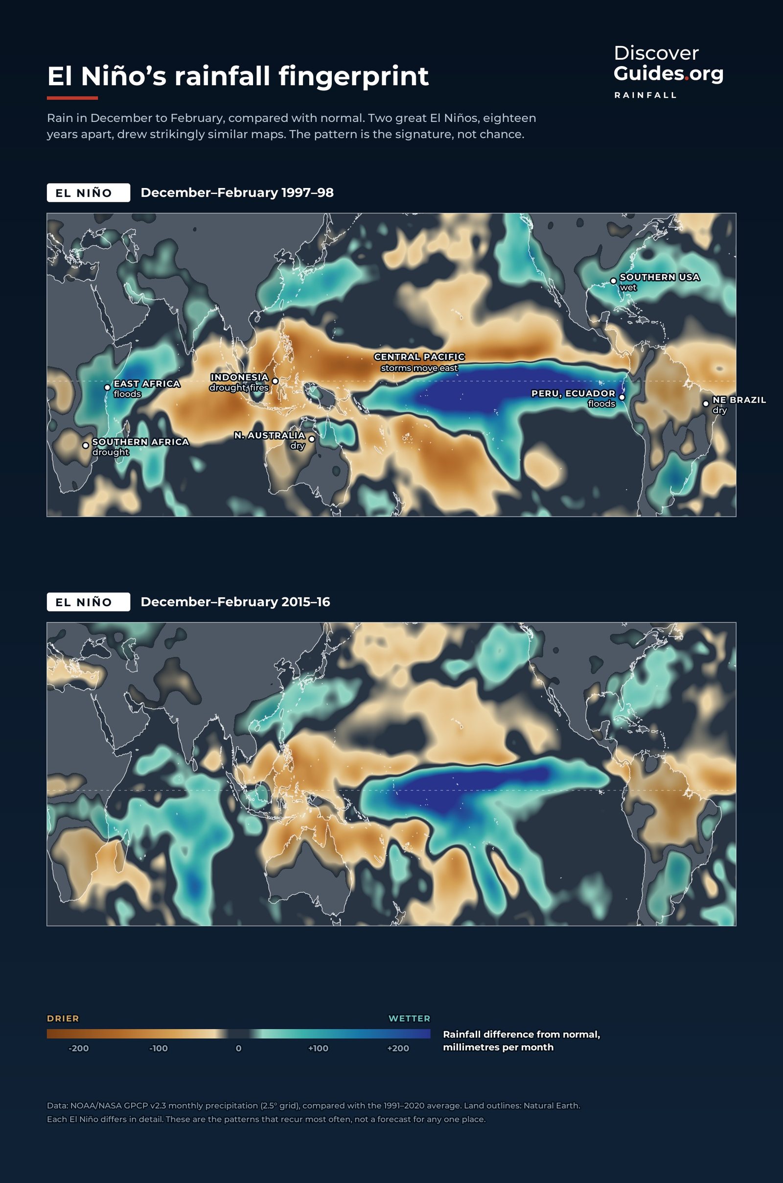
Why the location matters
The rain shifts to a different place, and the long-distance links change with it. A 2009 study in Science by Kim, Webster and Curry at Georgia Tech found that while classic events tend to suppress Atlantic hurricanes, central Pacific events were linked to more frequent Atlantic storms and a higher chance of landfall around the Gulf of Mexico and Central America (compare El Niño, Hurricanes and Typhoons).
India's monsoon is sensitive too. A 2006 study in Science by K. Krishna Kumar, Martin Hoerling and colleagues examined 132 years of Indian rainfall and found that El Niños with the warmest water in the central Pacific were more effective at starving the monsoon than events centred near South America (see El Niño and the Indian Monsoon).
One phenomenon or two?
Scientists still debate whether Modoki is a separate phenomenon or one end of a continuum, which is why some prefer to describe each event by the temperature gradient between Niño 4 and Niño 1+2 (see How El Niño Is Measured). The opposite extreme, a warming confined to the coast of Peru, is described in Coastal El Niño.
The 2026-27 event is not a Modoki. By NOAA's September 2026 figures, Niño 3.4 stood at +2.1 °C, Niño 3 at +3.0 °C and Niño 1+2 at +3.9 °C: warming from the central Pacific right to the coast of South America.
Questions
What is El Niño Modoki?
El Niño Modoki, or central Pacific El Niño, is an event in which the strongest warming sits near the date line in the central Pacific rather than off South America. The name means "similar but different" in Japanese.
What was the strongest central Pacific El Niño?
A 2010 NASA-NOAA study by Lee and McPhaden called 2009-10 the strongest central Pacific El Niño observed to date.
Does El Niño Modoki affect hurricanes?
A 2009 study in Science linked central Pacific El Niños to more frequent Atlantic hurricanes and a higher chance of landfall around the Gulf of Mexico and Central America, unlike classic events.
Is the 2026-27 El Niño a Modoki?
No. As of NOAA's September 2026 figures, the warmth reached from the central Pacific to the coast of Peru, with Niño 1+2 at +3.9 °C.


