At a glance
What the IPCC says
The IPCC's Sixth Assessment Report, published in 2021, judges it virtually certain that ENSO will remain the dominant mode of year-to-year climate variability in a warmer world. On the strength of El Niño's sea surface temperature swings it finds no consensus: across generations of climate models there is no agreement on whether they will grow or shrink this century, and its confidence in how ENSO itself will change is low.
Rainfall is a different story. The IPCC judges it very likely that, under intermediate to very high emissions, rainfall variability linked to ENSO over the east-central tropical Pacific will increase significantly. A warmer tropical Pacific is a wetter one, so the same shift in winds moves more water.
More giants ahead?
In 2014 a team led by Wenju Cai of Australia's CSIRO projected in Nature Climate Change a doubling in the frequency of extreme El Niños, the kind that move deep convection into the normally dry eastern Pacific, because the eastern equatorial Pacific is projected to warm faster than the surrounding ocean. A 2015 follow-up projected extreme La Niñas rising from about one every 23 years to about one every 13 years, about three-quarters of them in years after an extreme El Niño: bigger warm swings and harder whiplash afterwards.
Has ENSO already changed?
The IPCC report noted that ENSO variability since 1950 has been higher than in 1850-1950 and, according to reconstructions from fossil corals and other natural archives, higher than over the centuries back to about 1400. But natural swings also wax and wane over decades. In 2023 Cai and colleagues compared more than 40 climate models before and after 1960 and found a high likelihood that greenhouse gases had increased the amplitude of ENSO variability by up to 10 per cent since 1960.
Why might warming strengthen ENSO? Under greenhouse warming the upper tropical Pacific warms faster than deeper water. That sharpens the thermocline, making the ocean more sensitive to changes in the winds, so the Bjerknes feedback works harder (see The Thermocline and The Bjerknes Feedback). Researchers treat this as a strong hypothesis rather than a settled fact.
The cold tongue puzzle
There is a complication. Most climate models expected the eastern equatorial Pacific to warm faster than the west, in a pattern resembling El Niño. Observations since 1958 show something else. In a 2019 study in Nature Climate Change, Richard Seager and colleagues at Columbia University's Lamont-Doherty Earth Observatory found that the cold tongue of the eastern Pacific has not warmed, or has even cooled, while most of the ocean has warmed. The east-west contrast has strengthened, a pattern more like La Niña. Resolving this puzzle is one of the biggest open questions in climate science.
Spikes on a rising line
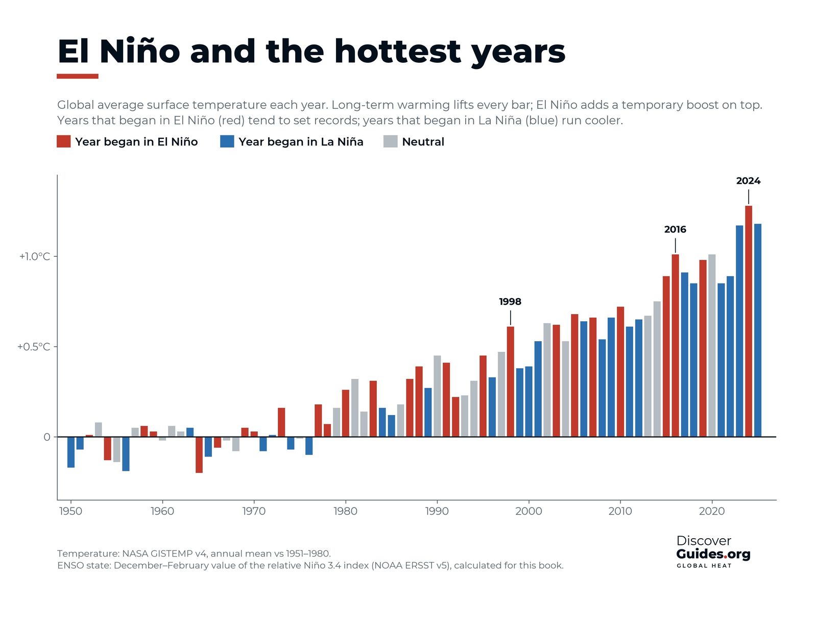
Whatever happens to ENSO itself, every El Niño now arrives on a warmer planet. The chart at the top of this page colours each year by the state of the Pacific: the red El Niño years sit near the top of each decade, the blue La Niña years near the bottom, and both rise together. 1998, 2016 and 2024 each set records in or just after El Niño years. Yet 2025, a La Niña year, was warmer than 2016, the El Niño record-breaker of only a decade earlier (see El Niño and Global Temperature).
| Question | Current understanding | Confidence |
|---|---|---|
| Will ENSO continue? | Yes, as the dominant mode of variability | Virtually certain (IPCC) |
| Will ENSO rainfall swings grow? | Yes, over the east-central tropical Pacific | Very likely (IPCC) |
| Will ENSO sea temperature swings grow? | Models disagree | Low (IPCC) |
| Will extreme El Niños become more frequent? | Doubling projected in some studies | Research finding |
| Has ENSO already strengthened? | Up to 10% since 1960, one study finds | Research finding |
| Will El Niño years break heat records? | Yes, on top of the warming trend | Observed |
A ruler that moves
Climate change has even forced scientists to rethink how they measure El Niño. As the whole ocean warms, a fixed baseline goes stale, so on 1 February 2026 NOAA moved its official monitoring to the relative index, RONI, which compares Niño 3.4 with the tropics as a whole (see How El Niño Is Measured). The aim is to measure El Niño itself, not the warming it rides on.
The giant of 2026-27 is both a natural event and a glimpse of the future. Copernicus reported that September 2026 was 1.63 °C above pre-industrial levels, with record September sea surface temperatures. Each El Niño now offers a preview of what an average year will feel like later this century (see The 2026-27 Super El Niño).
Questions
Is climate change making El Niño stronger?
Possibly. A 2023 study found greenhouse gases had likely increased ENSO's swings by up to 10 per cent since 1960, but the IPCC has low confidence in how ENSO's sea temperature swings will change and models disagree.
Will there be more super El Niños?
Some studies, such as Cai et al. (2014), project a doubling in the frequency of extreme El Niños under greenhouse warming. This is a research finding, not a settled conclusion.
Does El Niño cause global warming?
No. El Niño temporarily releases heat the ocean has already stored, adding roughly a tenth of a degree or more for a year or so. The long-term rise comes from greenhouse gases.
What does the IPCC say about El Niño?
It is virtually certain ENSO will remain the dominant mode of year-to-year climate variability, very likely that ENSO-linked rainfall swings will increase over the east-central tropical Pacific, and it has low confidence in how the ocean swings will change.


