At a glance
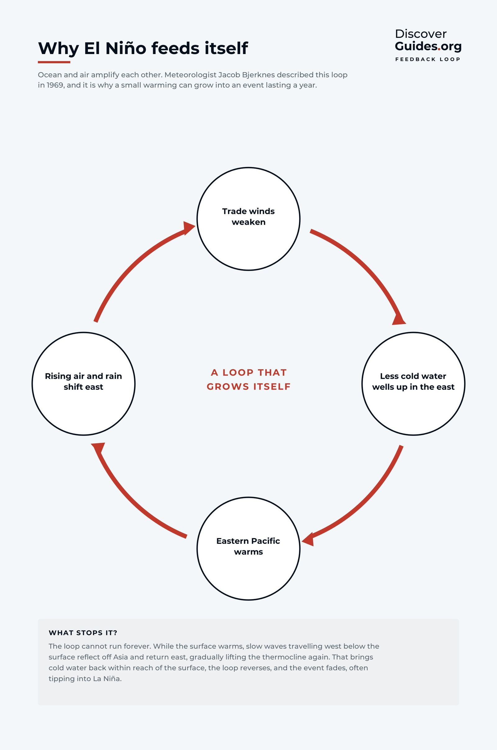
The tropical Pacific can hold itself in balance for years. The trade winds pile warm water in the west and lift cold water in the east, the temperature contrast drives the Walker circulation, and the circulation keeps the winds blowing (see The Walker Circulation). A feedback loop keeps that state stable. Push it the other way and the same loop drives it apart.
The chain reaction, step by step
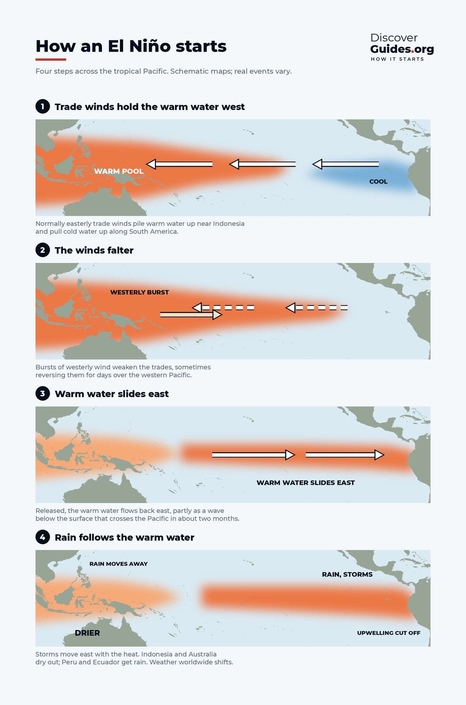
- 1. The winds falter. Westerly wind bursts relax or reverse the trade winds over the western Pacific.
- 2. Warm water slides east. A Kelvin wave carries the warm layer east and pushes the thermocline down off South America (see Kelvin Waves).
- 3. The east warms. Upwelling now brings up warm water, and the central and eastern Pacific heat up.
- 4. The storms follow. The air above becomes more buoyant and thunderstorms form further east than usual.
- 5. The contrast shrinks. With the east warmer, the east-west temperature difference falls and the Walker circulation weakens.
- 6. The winds weaken again. Weaker trade winds mean even less upwelling, so the surface warms more, and the loop runs again.
This self-reinforcing loop is known as the Bjerknes feedback. NOAA's Climate.gov notes that weak events may only push enhanced rainfall to around the International Date Line, while strong events can drag it all the way to the coasts of Ecuador and Peru.
Who was Jacob Bjerknes?
Jacob Bjerknes was a leading figure of Norway's Bergen School of meteorology. He helped build the theory of mid-latitude storms in the 1920s before moving to the University of California, Los Angeles. The El Niño of 1957-58 coincided with the International Geophysical Year, and the measurements made then showed him that the warm water stretched far out into the central Pacific, not just along the coast of Peru (see Who Discovered El Niño?).
In 1966 and then in 1969, in a paper titled "Atmospheric teleconnections from the equatorial Pacific", he set out the idea that still anchors the science: the warm current off Peru and the low phase of Gilbert Walker's Southern Oscillation were two faces of one ocean-atmosphere system, today called ENSO.
Why El Niño peaks around Christmas
The feedback does not run equally well all year. NOAA explains that the average state of the Pacific favours ocean-atmosphere coupling in the northern summer and autumn, when the east-west contrast in sea temperature builds to its autumn maximum, and least in spring, when it is at its minimum. So El Niño events usually grow through the second half of the year and are strongest in the northern winter.
That Christmas-time peak gave the phenomenon its name. Peruvian fishermen called the warm current that tended to arrive around Christmas El Niño, Spanish for "the little boy", in reference to the birth of Jesus.
A warm ocean is only half an El Niño
The feedback needs both partners. NOAA's Climate.gov points out that in some years the ocean and atmosphere disagree: the sea may look like El Niño while the winds and rain carry on as normal. Until both sides join in, the loop cannot get going. In 2014 a warm Kelvin wave raised hopes of an El Niño, but the winds never fully reversed and the event fizzled until 2015.
How the loop finally breaks
El Niño carries the seeds of its own end. As it matures, its heat is flushed away from the equator, draining the reservoir of warm water. Meanwhile the wind anomalies launch Rossby waves that travel west, reflect off the western Pacific and return east as a cold pulse beneath the surface. When that pulse arrives, the feedback runs in reverse. In May 1998 the trade winds returned and the sea at 0°, 125°W cooled by 8 °C in 30 days. The full sequence is in How Long Does El Niño Last?.
Questions
What is the Bjerknes feedback?
It is the self-reinforcing loop between the tropical Pacific Ocean and the atmosphere: weaker trade winds let the east warm, a warmer east weakens the east-west contrast, and a weaker contrast weakens the winds further. It is what turns a small warming into a full El Niño.
Who discovered the Bjerknes feedback?
The Norwegian-American meteorologist Jacob Bjerknes, in papers published in 1966 and 1969.
Why does El Niño peak in winter?
The Pacific favours ocean-atmosphere coupling in the northern summer and autumn, so events grow through the second half of the year and usually peak between November and January.
Does La Niña also involve the Bjerknes feedback?
Yes, in the other direction: stronger trade winds strengthen upwelling and cool the east, which increases the contrast and strengthens the winds further.


