At a glance
Rivers in the sky
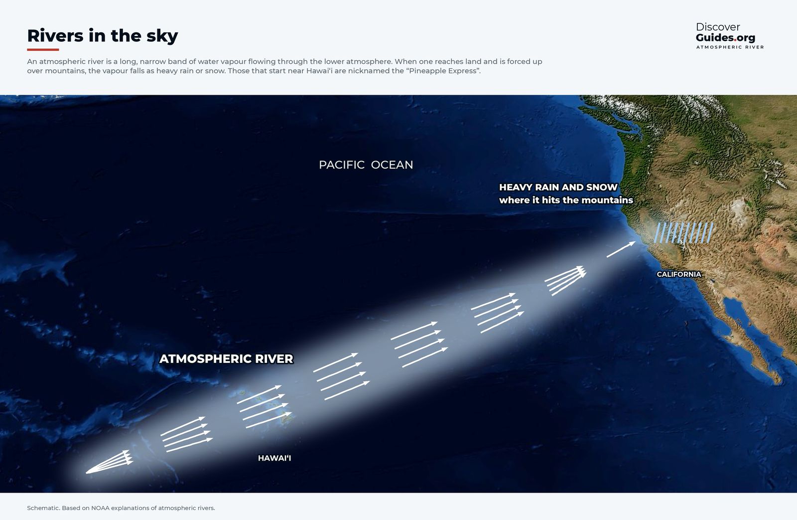
An atmospheric river is a long, narrow band of water vapour flowing through the lower atmosphere, on average 400 to 600 km wide. According to NOAA, a strong one carries roughly 7.5 to 15 times the average flow of liquid water at the mouth of the Mississippi. When it reaches the coast and is forced up over mountains such as the Sierra Nevada, the air cools and the vapour falls as heavy rain or snow.
NOAA estimates that on average 30 to 50% of the annual precipitation in the West Coast states falls during just a few atmospheric-river events. Those that draw moisture from the tropics near Hawaii, as in the graphic above, are nicknamed the Pineapple Express. Researchers at Scripps Institution of Oceanography rank them on a five-step scale, from AR1 (weak, mostly beneficial) to AR5 (exceptional, mostly hazardous). Most are beneficial: they fill reservoirs and build the snowpack. The strongest, especially when they stall, bring floods and landslides.
How El Niño loads the dice
El Niño does not create atmospheric rivers. It changes where the storm track runs. With the warmest water and the biggest thunderstorms shifted to the central Pacific, the subtropical jet stream tends to strengthen and stretch east across the southern United States, steering storms toward California and on to the Gulf Coast and Florida. The mechanics are in how El Niño bends the jet stream.
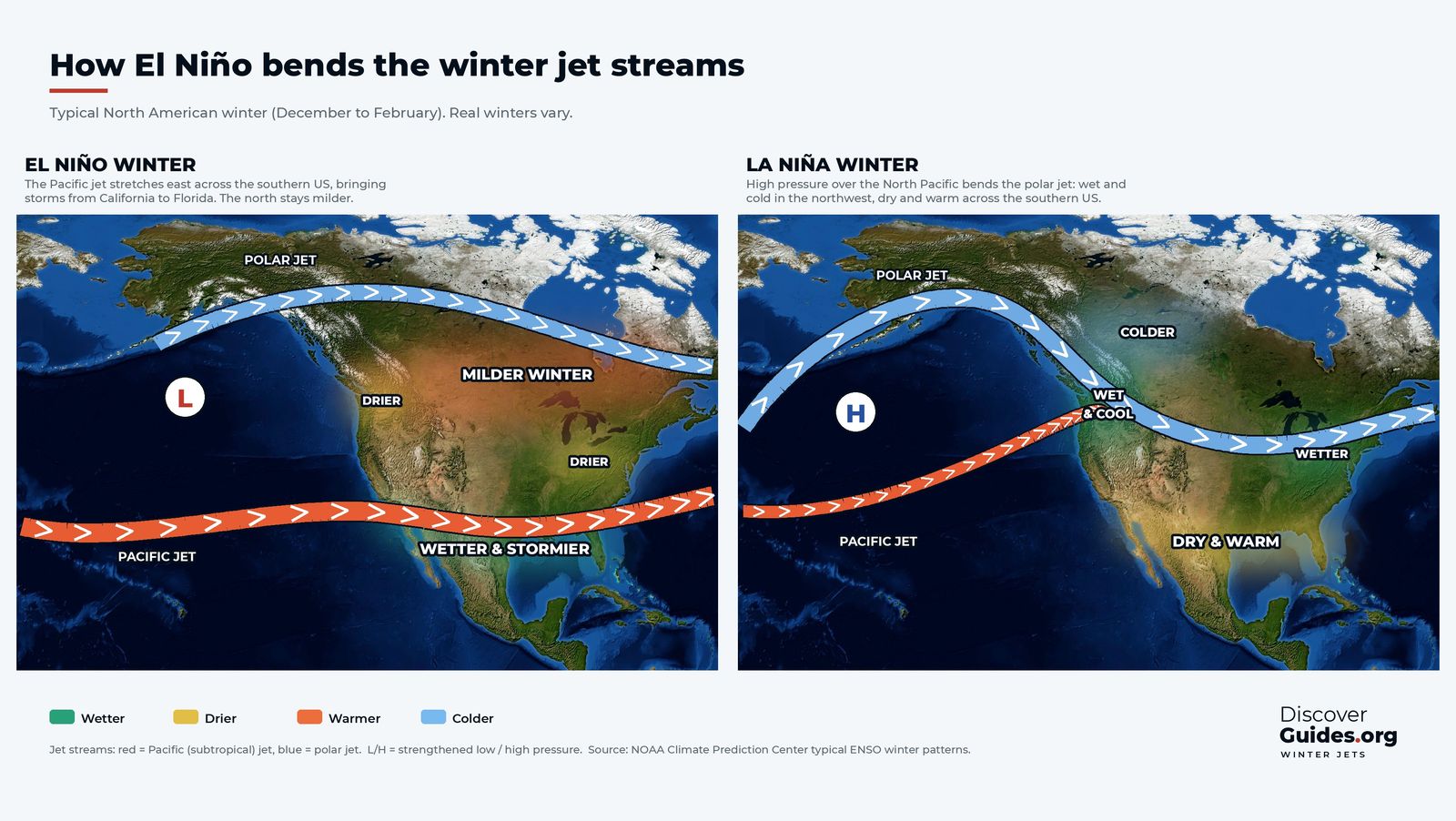
The signal is strongest and most reliable in Southern California and weaker farther north, where the odds can lean either way. It is a tilt, not a switch: a strong El Niño raises the chance of a wet winter in the south without guaranteeing one.
What the giant El Niños delivered
| Winter | What California got |
|---|---|
| 1982-83 | Storm after storm, with coastal flooding and erosion; NOAA puts the damage at about $2.2 billion |
| 1997-98 | A wet, stormy winter with floods and landslides; about $1.1 billion in damage, with months of warning to prepare |
| 2015-16 | A very strong El Niño, but a dry winter in Southern California; the north fared better |
| 2023-24 | Atmospheric rivers in February 2024 dropped more than half a normal year's rain on parts of Los Angeles in a few days |
2015-16 is the cautionary tale. Expectations were sky-high after 1997-98, and the drought-weary south stayed dry. A NOAA-led study published in 2018 found that the ocean pattern still favoured a wet winter, and that the dryness came mostly from random weather variability. The models had also signalled a weaker wet signal than in 1998. Read more in El Niño 2015-16 and El Niño 1997-98.
Snow matters as much as rain
California's water supply depends on the Sierra Nevada snowpack, which California's Department of Water Resources says supplies about 30% of the state's water in an average year, melting slowly into rivers and reservoirs through spring and summer. A cold storm that builds the snowpack is worth more than a warm one that falls as rain.
Warm atmospheric rivers can deliver rain high into the mountains and even onto existing snow, sending water downhill all at once. That raises the flood risk and leaves less stored for summer. Whether an El Niño winter brings snow or rain at elevation depends on the temperature of each storm, which a seasonal outlook cannot predict.
When rain becomes danger
California's flood risk in a stormy El Niño winter comes in several forms: rivers rising after days of rain, flash floods in canyons and washes, coastal flooding when storms coincide with high tides, and debris flows. The last is the most dangerous on slopes burned by recent wildfires, where scorched soil sheds water and mud and boulders can move fast with little warning.
SafetyNever drive or walk into floodwater: a few tens of centimetres of moving water can sweep away a car. If you live below a recent burn scar, know your evacuation route before the storm, follow National Weather Service flood and debris-flow warnings, and leave when local officials tell you to.
What NOAA expects for 2026-27
As of NOAA's October 2026 ENSO update, a strong to very strong El Niño was likely through January to March 2027. NOAA's winter outlook, issued in mid-October 2026, favours wetter-than-average conditions across the southern United States, from California to Florida, while stressing that a strong El Niño does not guarantee any particular outcome at any one place. The outlook is updated monthly by NOAA's Climate Prediction Center (cpc.ncep.noaa.gov); the next update is due on 19 November 2026.
For California, that means rising odds of a stormy winter, especially in the south, not a promise. One wet season also does not refill depleted groundwater on its own. The book Discover El Niño has a full chapter on atmospheric rivers, storms and floods, and the global pattern is in what El Niño means for weather around the world.
Questions
Does El Niño mean a wet winter in California?
It raises the odds, especially in Southern California, but does not guarantee it. 1982-83 and 1997-98 were very wet; the very strong El Niño of 2015-16 left Southern California dry.
What is an atmospheric river?
A long, narrow band of water vapour in the lower atmosphere, typically 400-600 km wide. When it hits mountains, the vapour falls as heavy rain or snow. A few of them supply 30-50% of the West Coast's yearly precipitation.
Does El Niño cause atmospheric rivers?
No. Atmospheric rivers happen every winter. El Niño shifts the jet stream and storm track south, which can steer more of them toward California.
What is the Pineapple Express?
A nickname for a strong atmospheric river that carries moisture from the tropics near Hawaii to the US West Coast.
What is NOAA's winter outlook for California in 2026-27?
NOAA's outlook, issued in mid-October 2026, favours a wetter-than-average winter across the southern US, including California, but the odds are updated monthly and nothing is guaranteed.


