At a glance
How a tropical cyclone is born
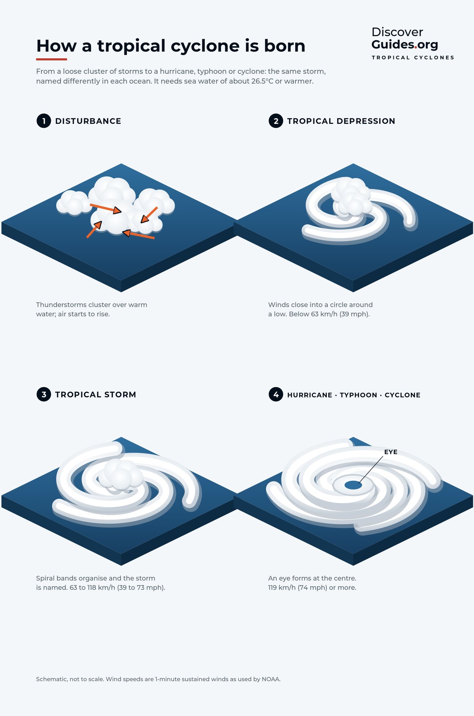
The graphic above shows the four stages. A loose cluster of thunderstorms over warm water starts to rotate around an area of low pressure. Once the winds close into a circle it is a tropical depression. At 63 km/h (39 mph) it becomes a tropical storm and gets a name. At 119 km/h (74 mph) it is a hurricane in the Atlantic and north-east Pacific, a typhoon in the north-west Pacific and a cyclone in the Indian Ocean and South Pacific.
Every one needs the same ingredients: sea water of about 26.5°C (80°F) or warmer, moist air, enough spin from the Earth's rotation, and weak wind shear, meaning winds that change little in speed or direction with height.
Why wind shear decides
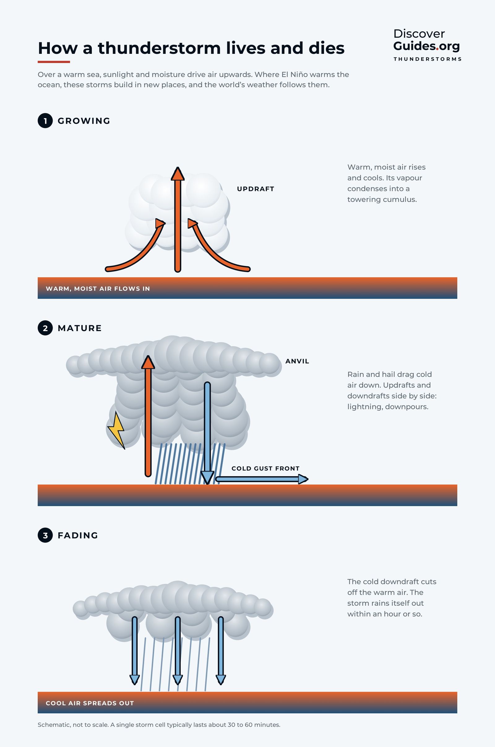
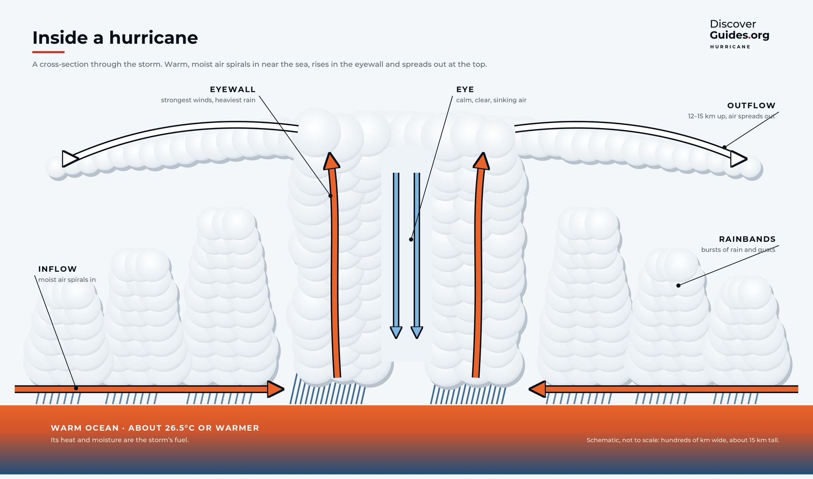
A tropical cyclone is a tall, upright heat engine. Strong wind shear tilts it, pulls warm air away from the core and can tear a young storm apart before it organises. Shear is the main lever El Niño pulls.
In an El Niño, the warmest water and the biggest thunderstorms shift east into the central Pacific. That changes the winds high above the Americas (the background is in how the planet's winds work). Over the Atlantic and Caribbean, NOAA explains, upper-level westerly winds strengthen, wind shear rises and the air becomes more stable, all of which suppress hurricanes. Over the central and eastern Pacific the opposite happens: shear weakens and storms find it easier to grow.
Basin by basin
| Ocean basin | What El Niño tends to do |
|---|---|
| Atlantic and Caribbean | Fewer and weaker hurricanes on average, as wind shear rises and the air turns more stable |
| Eastern and central North Pacific | More active seasons, with weaker shear; the hurricane risk around Hawaii rises |
| Western North Pacific | Typhoons form farther south-east, tend to last longer and grow stronger; fewer form in the north-west of the basin |
| Australian region | Fewer tropical cyclones on average, as the warmest water moves away from northern Australia |
| South Pacific islands | Cyclone activity shifts east, raising the odds for islands such as French Polynesia |
The western Pacific pattern follows the warm water. With the warm pool stretched east, typhoons are born closer to the dateline and travel farther over warm ocean before reaching land, which gives them more time to strengthen. In the Australian region, the Bureau of Meteorology notes that around 11 tropical cyclones form in an average season; in El Niño years the odds tilt toward fewer. In the very strong El Niño of 1982-83, several cyclones struck French Polynesia, where they are normally rare.
Timing matters
The Atlantic hurricane season runs from June to November and peaks from August to October. That is when a developing El Niño is usually growing fast, so its effect falls on the same year's season. 1997 is the classic case: as the giant El Niño built, the Atlantic had a below-normal season while the eastern Pacific was busy. La Niña tends to do the reverse, lowering wind shear over the Atlantic and favouring more hurricanes there.
In the southern hemisphere the season runs from about November to April, so it overlaps the months when El Niño is usually at its peak. That is why the Australian and South Pacific effects are often the clearest in the year an El Niño matures.
Odds, not rules
El Niño is one influence among several. In the Atlantic, NOAA's research shows that in an era of generally high activity an El Niño year tends to give a near-normal season rather than a quiet one. 2023 proved the point: despite a strong El Niño, record-warm Atlantic water produced an above-normal hurricane season (more in El Niño 2023-24).
El Niño years in the eastern Pacific have produced some of the most extreme storms on record. Hurricane Patricia in October 2015, during the 2015-16 El Niño, reached sustained winds of about 345 km/h (215 mph), the strongest on record in the Western Hemisphere. Hurricane Otis in October 2023 grew from a tropical storm to a Category 5 hurricane in about a day before striking Acapulco.
SafetySeasonal odds say nothing about a single storm, and one landfall makes any season dangerous. Follow your national weather service, such as NOAA's National Hurricane Center, the Japan Meteorological Agency or Australia's Bureau of Meteorology, and obey local evacuation orders, whatever El Niño is doing.
What it means for 2026-27
As of NOAA's October 2026 update, El Niño was expected to keep strengthening through the end of 2026, with a strong to very strong event likely through January to March 2027. The southern hemisphere cyclone season, which runs from about November to April, is now unfolding under that influence, which on past form tilts the Australian region toward fewer cyclones and shifts South Pacific activity east. How the 2027 northern seasons turn out will depend on how fast the event decays; outlooks can change.
The full chapter on tropical cyclones, from the first thunderstorm to the eyewall, is in the book Discover El Niño. For the wider pattern of rain and drought, see what El Niño means for weather around the world.
Questions
Does El Niño mean fewer hurricanes?
In the Atlantic, usually yes: El Niño raises wind shear over the Atlantic and Caribbean, which suppresses hurricanes. In the eastern and central Pacific it tends to bring more.
Does El Niño affect typhoons?
Yes. In El Niño years, typhoons in the western North Pacific tend to form farther south-east, last longer and become more intense, while fewer form in the north-west of the basin.
Does El Niño increase hurricane risk in Hawaii?
It tends to. Weaker wind shear and warmer water in the central Pacific make hurricanes near Hawaii more likely in El Niño years.
Does El Niño affect cyclones in Australia?
Australia tends to see fewer tropical cyclones in El Niño years, because the warmest water moves away from the north of the country toward the central Pacific.


