At a glance
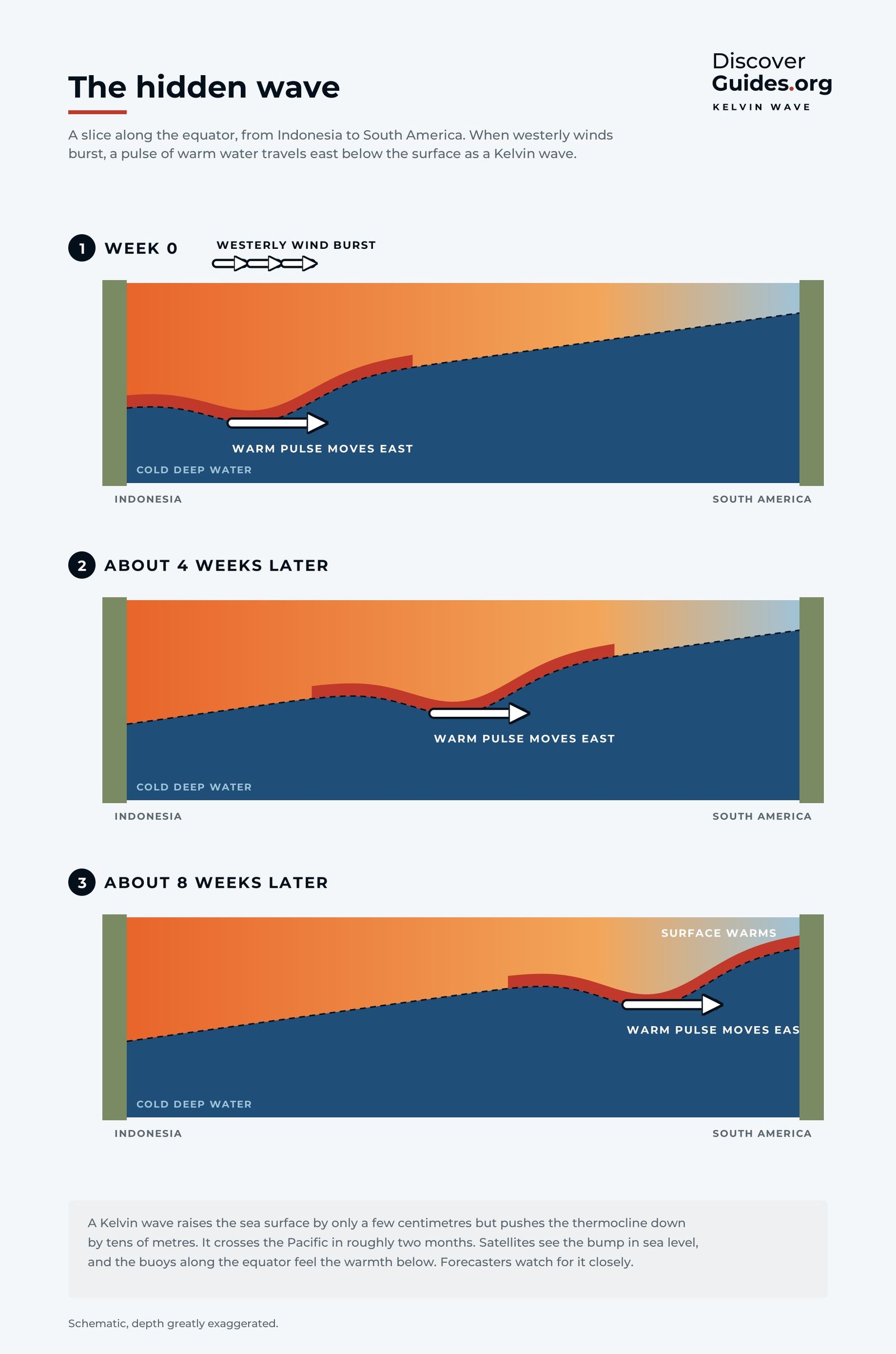
An oceanic Kelvin wave is a planetary-scale wave trapped close to the equator. It can span thousands of kilometres, it travels only eastward, and it does not curl or break like surf. At the surface it shows up only as a slight rise in sea level. Below, it appears as a dip in the thermocline, the boundary between warm upper water and the cold ocean beneath.
That hidden dip is what matters for El Niño. The book Discover El Niño calls the Kelvin wave the moment the warm water piled up in the western Pacific begins to slosh back towards the Americas, not as a current but as a wave.
What starts a Kelvin wave
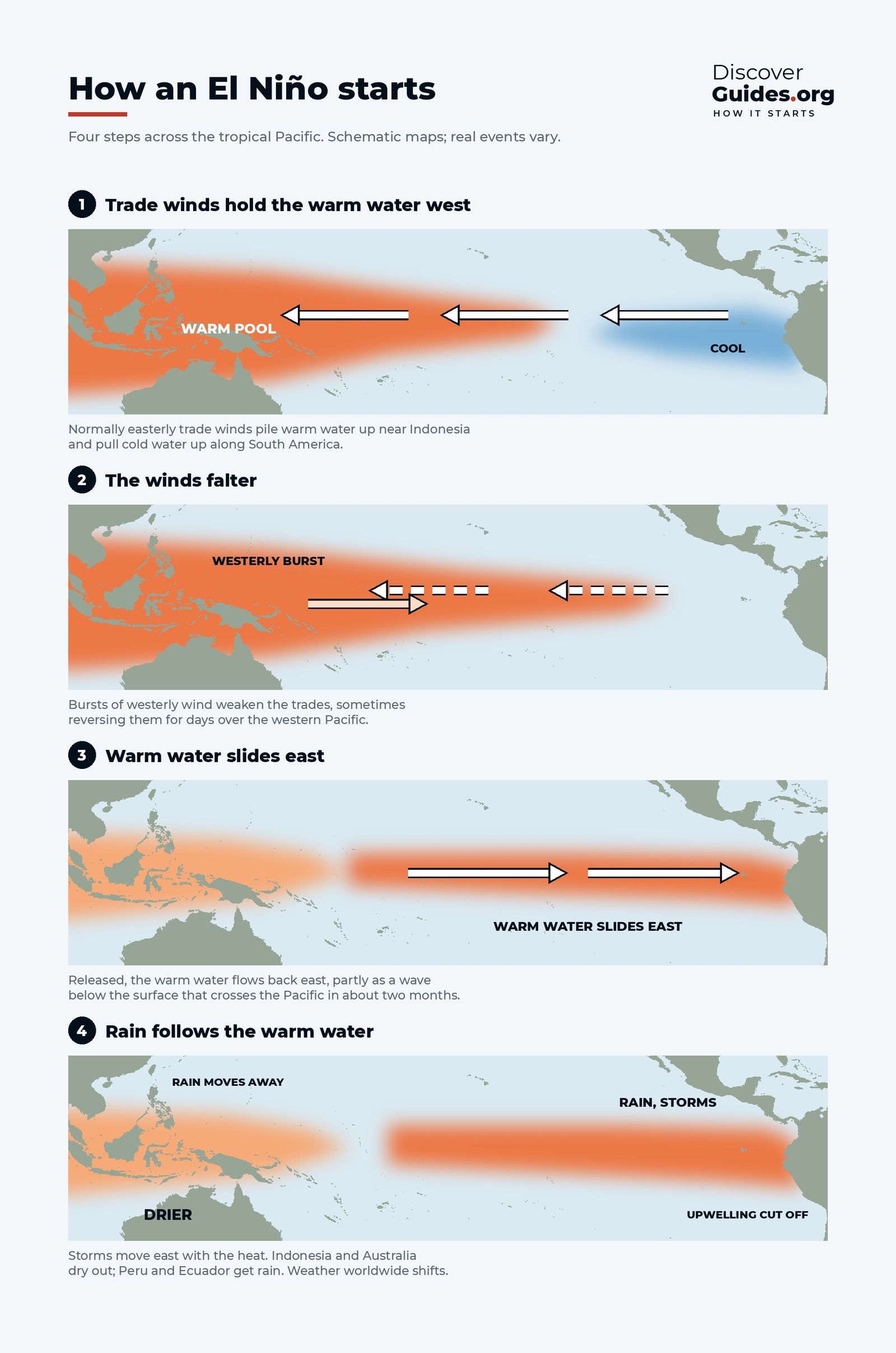
In a normal year the trade winds blow steadily from east to west along the equator and pile warm water up against Asia (see Global Wind Belts Explained). Every so often that pattern is interrupted by westerly wind bursts: spells of strong wind blowing the wrong way, from west to east, for days or weeks. They are often linked to the Madden-Julian Oscillation, a pulse of cloud and rain that travels east around the tropics.
With the trade winds briefly relaxed or reversed, the water piled up in the west starts to move. Each burst shoves warm surface water east and launches a downwelling Kelvin wave: a broad bulge of warm water travelling along the equator beneath the surface.
Why a wave you cannot see warms the sea
Off South America the thermocline normally sits only about 50 metres down, close enough for the trade winds to pull cold, nutrient-rich water up to the surface. A downwelling Kelvin wave pushes the thermocline deeper as it passes. Once it is too deep, the winds can only stir up warm water, so the surface of the eastern Pacific heats up.
Several waves can follow one another over many months, each adding warmth. Satellite altimeters track them as a slight rise in sea level moving east, as NASA's Jet Propulsion Laboratory has shown, and the buoys of the TAO/TRITON array record them as warming at depth long before anything changes at the surface.
| Downwelling Kelvin wave | Upwelling Kelvin wave | |
|---|---|---|
| Usually launched by | Westerly wind bursts | Strong easterly winds |
| Thermocline | Pushed deeper | Lifted closer to the surface |
| Effect in the east | Surface warms, upwelling cut off | Surface cools |
| Role in ENSO | Builds El Niño | Works against El Niño, can favour La Niña |
Kelvin waves in the great El Niños
The giant of 1997-98 is the textbook case. Westerly wind bursts began in late 1996, and through 1997 a series of increasingly strong bursts sent Kelvin waves across the Pacific in about two months each. By late that year they had pushed the thermocline in the eastern Pacific down by more than 90 metres, cutting off the cold upwelling. Every month from June to December 1997 then set a new sea temperature record in the eastern equatorial Pacific (see El Niño 1997-98).
A Kelvin wave is not a guarantee. In March 2014 NOAA issued an El Niño Watch after a significant downwelling Kelvin wave had warmed the waters beneath the central Pacific. The winds never fully reversed, and the event fizzled until the following year.
The 2026 Kelvin waves
The 2026-27 event was flagged months ahead largely because of what was happening below the surface. Heat content beneath the equatorial Pacific had been climbing since late 2025, and NOAA's discussions tracked a rise in subsurface temperature for six consecutive months before El Niño was declared on 11 June 2026. By October 2026 subsurface temperatures in the eastern Pacific topped +10 °C above average at depth. The latest numbers are in The 2026-27 Super El Niño.
Kelvin waves and the end of El Niño
Waves also help an El Niño die. The westerly wind anomalies of a mature event launch Rossby waves that travel west, reflect off the western edge of the Pacific and return east as a cold pulse beneath the surface. This delayed oscillator, proposed by Max Suarez and Paul Schopf in 1988, can end an event about six months after the winds that created it. The full life cycle is in How Long Does El Niño Last?.
Questions
What is a Kelvin wave in the ocean?
An oceanic Kelvin wave is a very large, slow wave trapped near the equator that travels only eastward. It raises sea level slightly and pushes the thermocline deeper as it passes, which warms the surface of the eastern Pacific.
How long does a Kelvin wave take to cross the Pacific?
About two to three months. In 1997 a series of waves crossed in about two months each.
Do Kelvin waves cause El Niño?
They are one of its main triggers. Westerly wind bursts launch downwelling Kelvin waves that carry warm water east. Whether an El Niño follows depends on the atmosphere joining in, as the failed start of 2014 showed.
Can you see a Kelvin wave?
Not from a boat. Satellites detect it as a slight rise in sea level moving east, and moored buoys measure the warming below the surface.


