At a glance
Stage 1: Developing
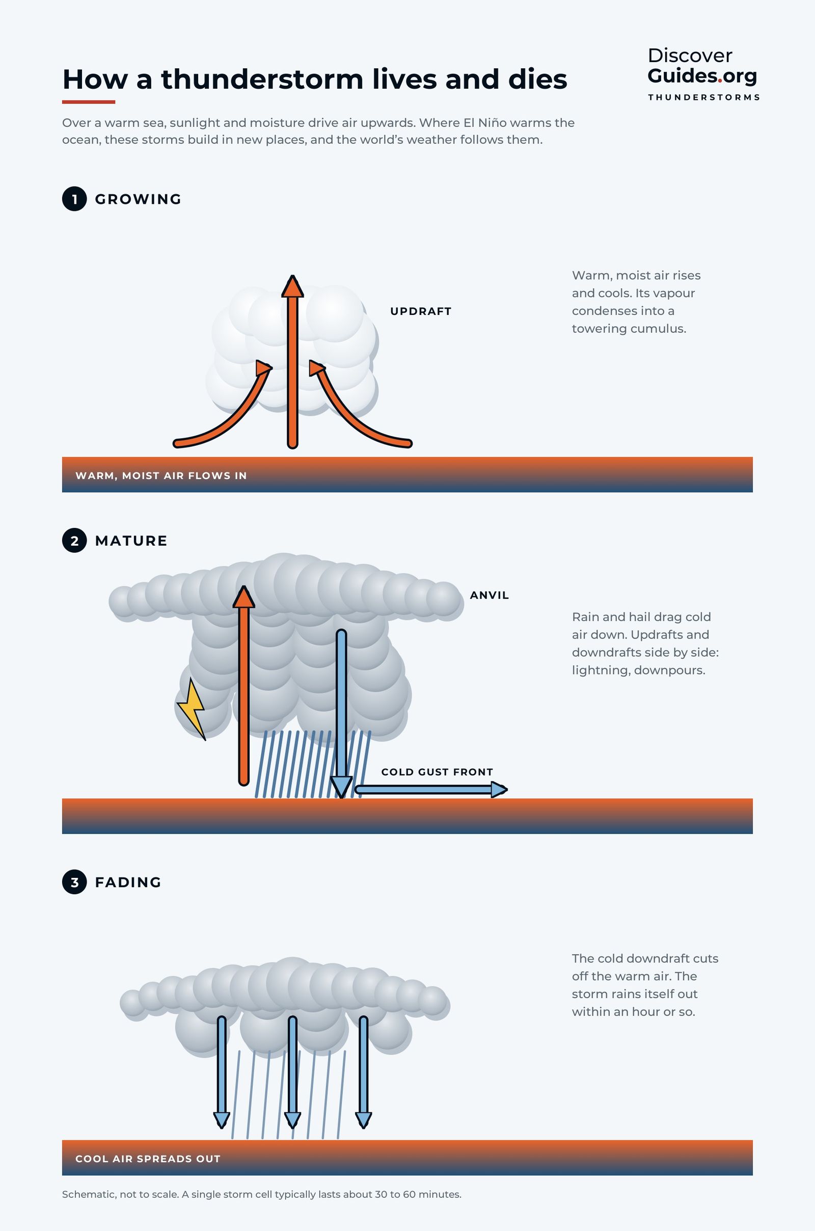
The US National Weather Service divides a thunderstorm's life into three stages. In the developing stage, a rising current of warm, moist air builds a towering cumulus cloud with little or no rain. As the vapour condenses it releases heat, which keeps the air buoyant and the cloud growing.
Stage 2: Mature
In the mature stage rain begins to fall, dragging down a cold downdraft alongside the updraft. The storm top can reach 12 to 18 km. This is the most dangerous stage, bringing the heaviest rain, hail, lightning and strong winds.
Stage 3: Dissipating
Eventually the downdraft overwhelms the updraft and cuts off the storm's supply of warm, moist air. In the dissipating stage only light rain and a ghostly anvil remain.
Why thunderstorms matter for the climate
Every tropical thunderstorm is a heat pump. About a quarter of the solar energy that reaches the planet leaves the surface through evaporation, mostly from warm tropical seas, and that energy is released high in the atmosphere when the vapour condenses into rain. The towering storms over the western Pacific warm pool are one of the engines of the planet's circulation (see What Is the ITCZ?).
El Niño is, at heart, a shift in where those thunderstorms form. When the warm water spreads east, the storms move with it, and the heat they release high up bends the jet streams thousands of kilometres away (see What Is the Jet Stream?).
From storms to floods
A single cell rarely floods a town. Flooding begins when cells keep forming over the same ground, one after another, for hours or days. That is exactly what a warm El Niño sea can do along a desert coast.
The coast of northern Peru is a desert because the cold Humboldt Current chills the air above it, keeping it too stable for rain clouds to grow. When El Niño warms the sea, that lid lifts. A study of the 1997-98 rainy season by Ken Takahashi found that rain at Piura came in discrete, intense events, linked to warm nearby seas and onshore westerly winds that pushed moist air up the slopes of the Andes.
| Place | Normal rain | In a strong El Niño |
|---|---|---|
| Chulucanas, Peru | Dry desert coast region | 3,905 mm, January-May 1983 |
| Tambo Grande, Peru | Dry desert coast region | About 4,500 mm, December 1997-May 1998 |
| Charles Darwin Station, Galápagos | 254 mm a year | 3,264 mm, October 1982-July 1983 |
Where the Piura and La Leche rivers overflow, their water collects in a temporary lagoon in the Sechura Desert that local people call La Niña. During the 2017 coastal El Niño it reached 2,172 square kilometres holding about 5 cubic kilometres of water. The full story is in El Niño in Peru: Floods and Fisheries.
SafetyNever drive into flood water, which is often deeper and faster than it looks. During an El Niño wet season, check your national weather service for heavy-rain alerts and know whether your home sits in a mapped flood zone.
Questions
How long does a thunderstorm last?
A single thunderstorm cell lives about 30 to 60 minutes. Storm systems last longer because new cells keep forming.
What are the three stages of a thunderstorm?
Developing (a towering cumulus with little rain), mature (heavy rain, hail, lightning and strong winds) and dissipating (light rain and a fading anvil).
Why does El Niño bring rain to the Peruvian desert?
El Niño warms the sea off northern Peru, removing the cold lid that normally stops rain clouds growing. Warm, moist air pushed up the Andes then produces intense thunderstorms.
How high do thunderstorms reach?
A mature storm top can reach 12 to 18 km. In the tropical rain belt, storm tops can exceed 16 km.


