At a glance
Why El Niño dries Australia
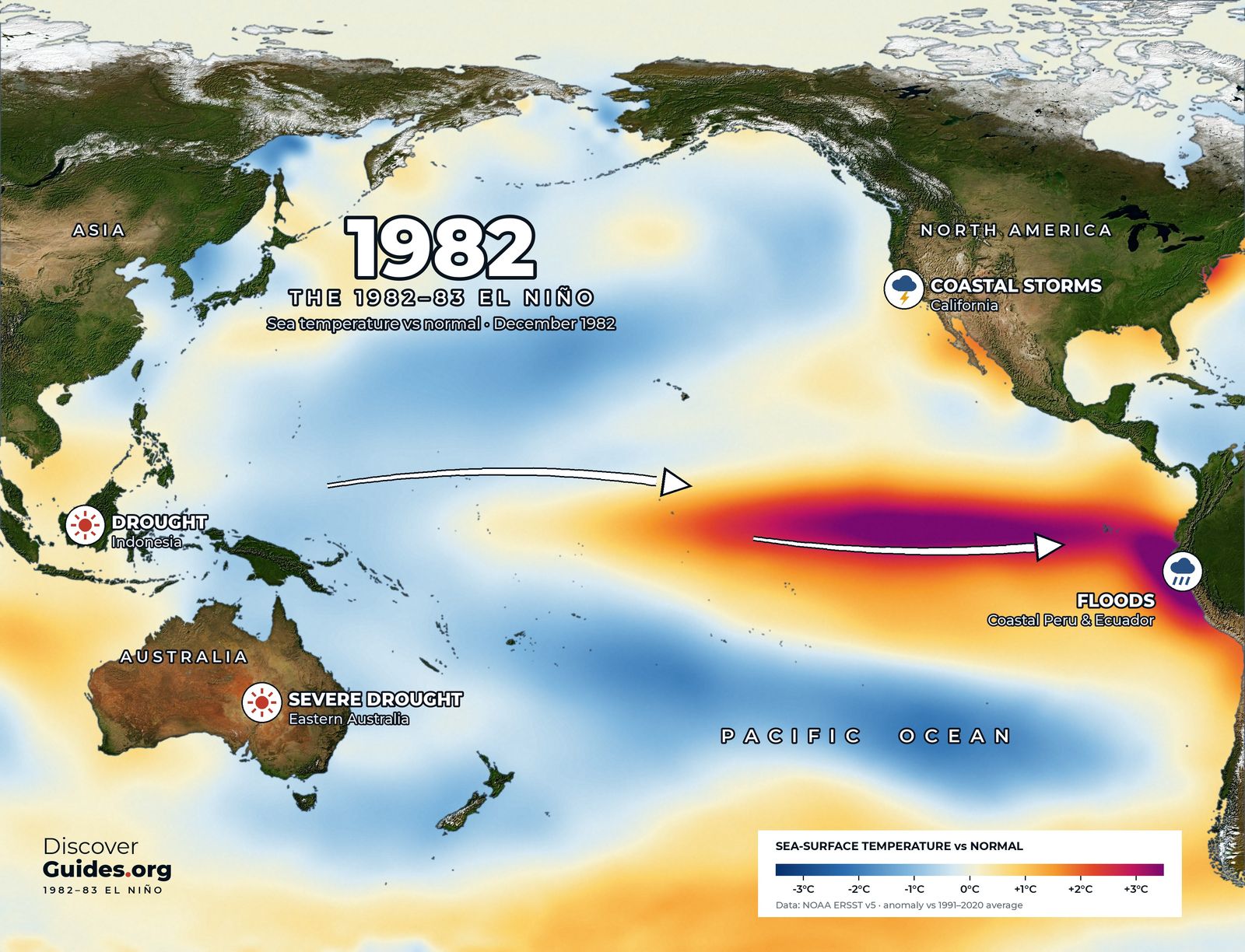
In normal years the warmest water in the Pacific sits north of Australia, and the air above it rises into rain clouds. During El Niño the warm water and the rain move east into the central Pacific, and sinking, drying air settles over the continent. The Bureau of Meteorology reports that winter-spring rainfall is usually reduced, especially across the eastern and northern parts of the continent.
| Effect | Typical El Niño change |
|---|---|
| Murray-Darling Basin winter-spring rain | Averages 28% below normal across all El Niños since 1900 |
| Frost, southern NSW and northern Victoria | 15-30% more frosts than average |
| Peak snow depth, Spencers Creek | Averages 35 cm lower |
| Fire danger | Rises in the south-east |
| Tropical cyclones | Fewer; about half as likely to cross the Queensland coast |
| Northern monsoon | Tends to arrive later |
1982-83: the benchmark drought
The map at the top of this page shows the Pacific at the peak of the 1982-83 El Niño. In the winter of 1982 the Murray-Darling Basin, the country's food bowl, received just 27 mm of rain, its driest in 116 years of records, at a cost of about A$3 billion in lost farm output. On 16 February 1983, after years of drought in Victoria, the Ash Wednesday bushfires killed 47 people in Victoria and 28 in South Australia (see El Niño 1982-83).
Not every El Niño is a drought
Writing for NOAA in 2015, Andrew Watkins of the Bureau of Meteorology noted that of 26 El Niño events since 1900, 17 brought widespread drought, about two in three. Event strength does not predict the rainfall deficit. In 2015, during one of the strongest events on record, inland eastern Australia still had an average or even wetter winter, because a very warm Indian Ocean fed moisture in from the west. Nationally that winter was 16 per cent drier than normal, but the Murray-Darling Basin received near-average rain.
The Indian Ocean partner
Australia sits on the doorstep of both oceans. A positive Indian Ocean Dipole, with cooler water off Java and Sumatra, adds to El Niño's drying. August to October 2023, under El Niño and a strong positive IOD, was Australia's driest three-month period on record. The 2019 positive IOD, the most extreme in at least 40 years, helped set the stage for the catastrophic bushfire season even with the Pacific close to neutral (see El Niño and the Indian Monsoon).
2026: two drivers at once
In 2026 the signal arrived with a partner. The Bureau declared El Niño on 16 June 2026, noting that around half of the models it surveyed showed a peak among the highest observed since 1950. Its 27 October update reported a positive Indian Ocean Dipole under way, at +0.69 °C for the week ending 25 October and above the +0.4 °C threshold for seven weeks running, with the 30-day Southern Oscillation Index at −16.6. Both drivers tend to dry eastern and southern Australia in spring, though the Bureau stressed that a strong Pacific signal does not guarantee strong local impacts.
The flip side: La Niña
La Niña does the reverse. The record 2010-11 La Niña made April 2010 to March 2012 Australia's wettest 24-month period on record, and the triple dip of 2020-23 gave Sydney its wettest year ever in 2022 (see The Triple-Dip La Niña).
Local tipFor farm and water decisions, use the Bureau of Meteorology's Climate Driver Update and seasonal outlooks, which combine the Pacific and the Indian Ocean, rather than the Niño 3.4 number alone.
To see the places in this story for yourself, our guide Discover Australia: The Great Barrier Reef takes you there.
Questions
Does El Niño always cause drought in Australia?
No. Of 26 El Niños since 1900, 17 brought widespread drought, about two in three. In 2015 inland eastern Australia had an average or wetter winter despite a very strong El Niño.
What does El Niño do to Australia?
It usually reduces winter-spring rain in the east and north, raises fire danger in the south-east, brings more frosts and less snow in the south-east, and means fewer tropical cyclones and a later northern monsoon.
What was Australia's worst El Niño drought?
1982 stands out: the Murray-Darling Basin received just 27 mm in winter, its driest in 116 years, and the Ash Wednesday bushfires followed in February 1983.
Did Australia declare El Niño in 2026?
Yes. The Bureau of Meteorology declared El Niño on 16 June 2026, and by late October a positive Indian Ocean Dipole was also under way.


