At a glance
The six ingredients
NOAA's National Weather Service lists the conditions a tropical cyclone needs:
- Warm water: at least about 27 °C (80 °F) at the surface, extending some 46 m down, so churning waves cannot simply stir up cold water.
- An unstable atmosphere: air that keeps rising once lifted, building tall thunderstorms.
- Moist mid-levels: humid air several kilometres up, so storms are not choked by dry air.
- Distance from the equator: at least about 480 km, so Earth's rotation can set the storm spinning.
- A seed: a pre-existing disturbance, such as a tropical wave or a cluster of thunderstorms.
- Low wind shear: little change in wind speed and direction with height, so the storm stays upright.
From cluster to hurricane
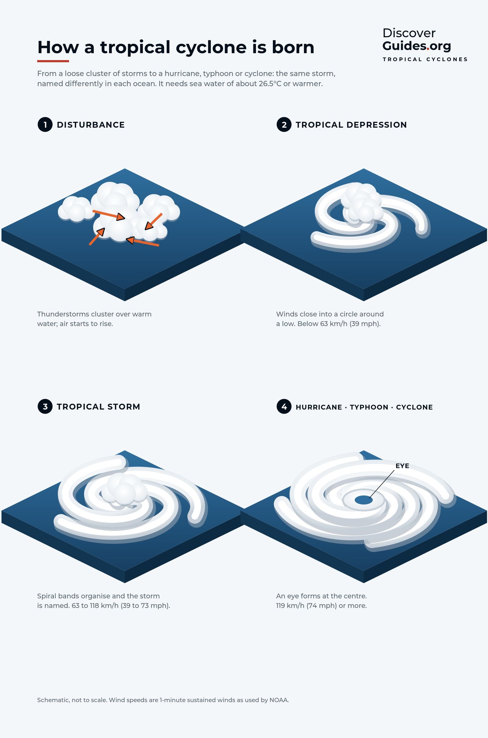
Most storms begin as a tropical disturbance: an organised cluster of thunderstorms that lasts at least 24 hours. With a closed circulation it becomes a tropical depression, with winds up to about 61 km/h. At 63 km/h it becomes a tropical storm and receives a name. At 119 km/h it becomes a hurricane in the Atlantic and eastern Pacific, a typhoon in the western North Pacific, and a cyclone in the Indian Ocean and South Pacific.
| Category | Sustained winds (km/h) | Sustained winds (mph) |
|---|---|---|
| 1 | 119-153 | 74-95 |
| 2 | 154-177 | 96-110 |
| 3 (major) | 178-208 | 111-129 |
| 4 (major) | 209-251 | 130-156 |
| 5 (major) | 252 or more | 157 or more |
The Saffir-Simpson Hurricane Wind Scale above is used by the US National Hurricane Center. Storms of Category 3 and above are called major hurricanes because of their potential for significant loss of life and damage.
Inside a hurricane
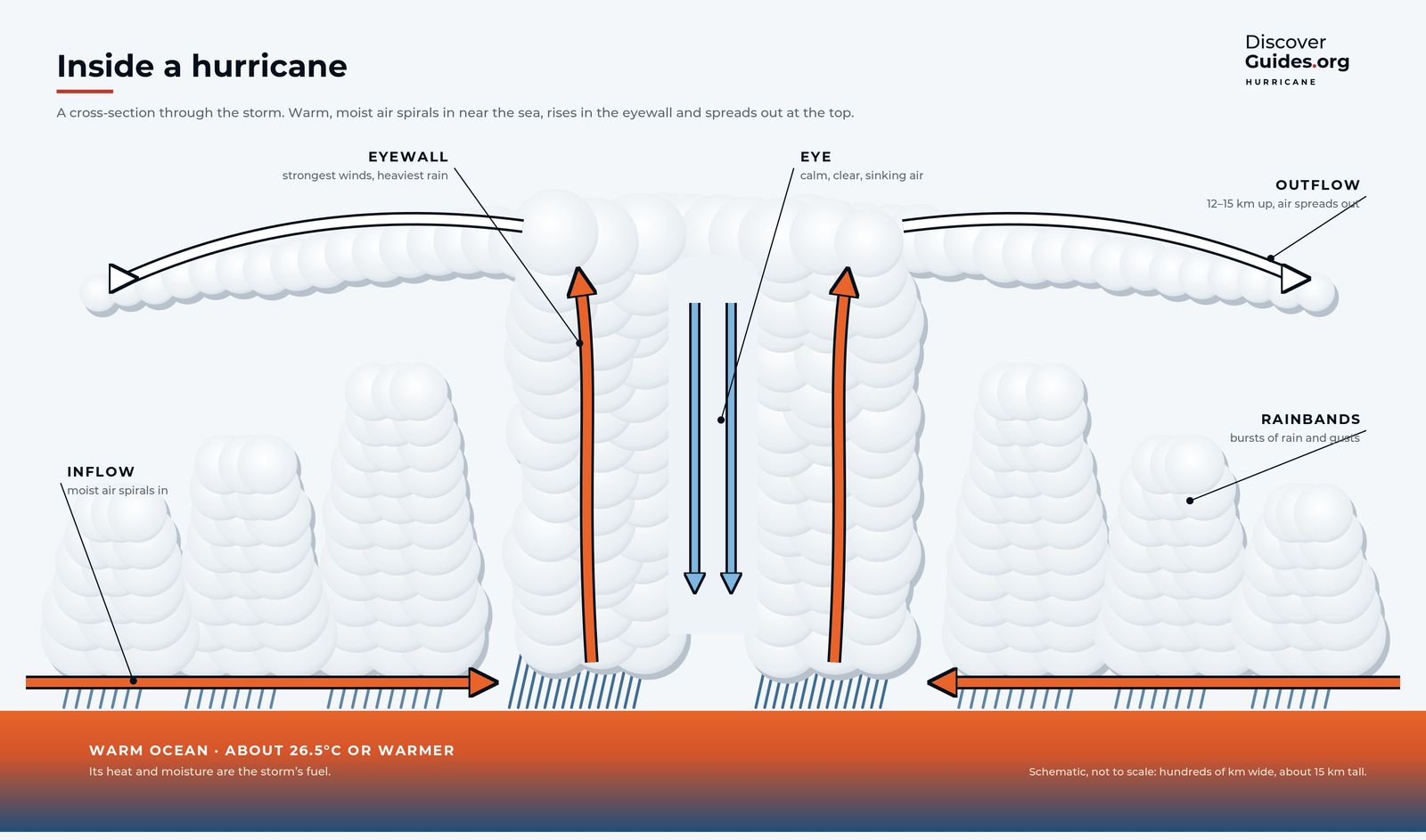
Air spirals in toward the centre near the sea surface, counterclockwise in the Northern Hemisphere and clockwise in the Southern, then rises and flows out at the top. At the heart is the eye, typically 30 to 65 km across, where air sinks and winds usually fall below about 25 km/h. Around it stands the eyewall, a ring of towering thunderstorms with the heaviest rain and usually the strongest winds. Beyond it, curved rainbands spiral outward, bringing bursts of rain, gusts and sometimes tornadoes.
A typical storm is about 480 km wide. In a large one, hurricane-force winds can reach more than 240 km from the centre. Size and strength are separate qualities: a compact storm can be ferocious, and a sprawling one weak.
Rapid intensification
The most dangerous storms strengthen faster than forecasts and evacuations can keep up. Hurricane Patricia's winds rose by about 195 km/h in 24 hours on 22-23 October 2015, a record, peaking at about 345 km/h with a central pressure of 872 hPa, the lowest on record in the Western Hemisphere. Hurricane Otis gained about 165 km/h in 21 hours in 2023 before hitting Acapulco at night as a Category 5. Both grew in the eastern Pacific, in El Niño years.
What El Niño does to hurricanes
| Basin | Typical El Niño effect | Main reason |
|---|---|---|
| North Atlantic | Fewer hurricanes | Stronger wind shear, sinking air |
| Eastern and central North Pacific | More and stronger hurricanes | Weaker shear, warmer water |
| Western North Pacific | Stronger, longer-lived typhoons | Genesis shifts south-east |
| Australian region | Fewer cyclones, later first landfall | Activity shifts east |
| Central South Pacific | More cyclones near French Polynesia | Warm water and storms shift east |
The brake on the Atlantic is strong but not absolute: in 2023 a strong El Niño met record warmth in the tropical Atlantic, and the season still produced 20 named storms. The full basin-by-basin story is in El Niño, Hurricanes and Typhoons.
SafetyRapidly intensifying storms leave little time to prepare. In a hurricane season, follow your national weather service and local evacuation orders, not the strength a storm had yesterday.
Questions
What is the difference between a hurricane, a typhoon and a cyclone?
They are the same kind of storm. It is called a hurricane in the Atlantic and eastern Pacific, a typhoon in the western North Pacific, and a cyclone in the Indian Ocean and South Pacific.
How warm does the sea need to be for a hurricane?
At least about 27 °C (80 °F) at the surface, with that warmth extending roughly 46 metres down.
What is the eye of a hurricane?
The calm centre of the storm, typically 30 to 65 km across, where air sinks and winds usually fall below about 25 km/h. It is surrounded by the eyewall, where winds are strongest.
Does El Niño cause more hurricanes?
In the eastern and central Pacific, yes. In the Atlantic, El Niño usually means fewer hurricanes because it strengthens the wind shear that tears storms apart.


